Municipal Heritage Site
Tanner's Crossing
Minnedosa, Manitoba
Also known as Parc Centennial, Centennial Park
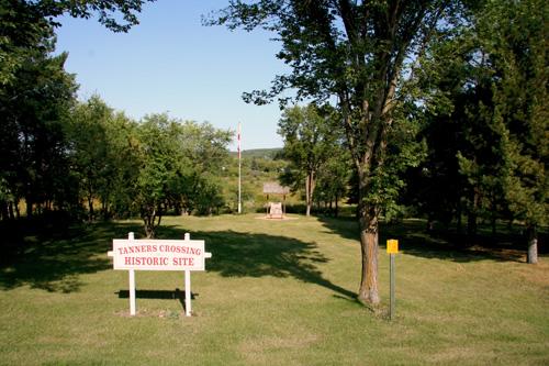
View of plaques at Tanner's Crossing, Minnedosa, 2006
Photo: Historic Resources Branch, Manitoba Culture, Heritage and Tourism, 2006
- Recognized
- 1993
- By
- Local government
The register’s text, word for word
Description
Tanner's Crossing, a former toll ferry site on the Carlton Trail, encompasses a large area of gently rolling park land straddling the Little Saskatchewan River in Minnedosa. The municipal designation applies to two adjacent parcels of land (on either side of the river) totalling approximately 6,000 square metres.
Heritage value
Tanner's Crossing, the birthplace of Minnedosa, a regional centre in the Parkland area, marks the point where Aboriginal peoples, fur traders and settlers crossed the Little Saskatchewan River along the Carlton Trail between Fort Garry (east) and Fort Edmonton (west) and where John and Catherine Tanner established a toll ferry, stopping house and post office beginning in 1872. These services spurred other settlement and economic activity in the area, eventually leading to the incorporation of the Town of Minnedosa in 1883. During Manitoba's centenary in 1970, the crossing site was celebrated and preserved through its inclusion in a municipal park.
SourceTown of Minnedosa By-law No. 2295, November 1, 1993
Character‑defining elements
Key elements that define the site character of Tanner's Crossing include:
- its location on the site of John and Catherine Tanner's ferry crossing along a portion of the Little Saskatchewan River now surrounded by Minnedosa
Key elements that define the historical and archaeological character and commemorative function of Tanner's Crossing include:
- the more gently sloping sides of the riverbank at the point of the crossing compared with the relatively steeper sides along other riverbank areas nearby
- the presence at the point of the river crossing of a natural raised gravel bed in the river bottom
- the largely natural character of the gently rolling landforms, vegetation, river features, etc.
- all surface and/or subsurface remains associated with Native peoples, traders, settlers, the Tanners and other users of the crossing point
- the public access, including walking paths, monuments and other structures on the site related to public use and education, etc.
End of the register’s text
Location
Minnedosa, Manitoba, R0J, Canada
50.24842° N, 99.83151° W
Get directions (opens in a new tab)Being on the register doesn’t make a place open to visitors. Many are private homes or businesses; please view them from the street.

Loading map…
Similar places
Places whose register descriptions are closest to this one.
 Crippled Creek Crossing SiteGravelbourg RM 104, Saskatchewan
 Boundary Commission Trail - Turtlehead Creek CrossingDeloraine, Manitoba
 Sourisford ParkMelita, Manitoba
 The Forks National Historic Site of CanadaWinnipeg, Manitoba
 Riverside ParkWhitewater, Manitoba
 T.C. Douglas Calvary CentreWeyburn, Saskatchewan
From the Canadian Register of Historic Places, as last updated on December 12, 2025. The register’s text is shown word for word.