Municipal Heritage Site
Riverside Park
Whitewater, Manitoba
Also known as Lisk Campbell Heritage Park, Parc du patrimoine Lisk Campbell
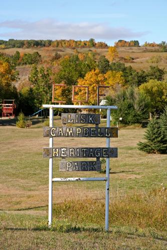
View of sign at Riverside Park, Minto area, 2006
Photo: Historic Resources Branch, Manitoba Culture, Heritage, Tourism and Sport, 2006
- Recognized
- 1991
- By
- Local government
The register’s text, word for word
Description
Riverside Park is a large recreation area on both sides of the Souris River near Highway 10 north of Minto. The triangular-shaped park includes a stone cairn, interpretive signage, playground and picnic sites set among mature trees along the south riverbank, open playing fields behind and an undeveloped green space on the opposite bank. The municipal designation applies to the approximately 23-hectare site.
Heritage value
Riverside Park, also known as Lisk Campbell Heritage Park, honours Thomas Liskum Campbell (1870-1956), one of the first homesteaders in the Riverside district of the Rural Municipality of Whitewater, who emigrated to Manitoba from Ontario in the 1880s. 'Lisk' was a well-known entrepreneur and sportsman and one of the district's first ferry operators. In 1931, on the north side of this site, which he named Riverside Park, Campbell established a store, coffee shop, dance hall and sports grounds, taking advantage of proximity to a newly built road bridge over the Souris River. Although the north side of the park is no longer in active use, the south section has served ever since as a popular local recreation and picnic area.
SourceRural Municipality of Whitewater By-law No. 8807, September 11, 1991
Character‑defining elements
Key elements that define the site character of Riverside Park include:
- the location on the banks of the Souris River close to Highway 10, as initially chosen by Thomas Liskum Campbell
Key elements that define the park's heritage character include:
- the stone cairn with a plaque honouring Thomas Liskum Campbell and a decorative finial showing the Canadian Order of Foresters logo
- the name 'Riverside Park' given by Campbell
- the amenities for public recreation, including a picnic shelter, playground, open fields, etc.
- the public access
End of the register’s text
Location
Whitewater, Manitoba, R0K, Canada
49.50117° N, 99.99213° W
Get directions (opens in a new tab)Being on the register doesn’t make a place open to visitors. Many are private homes or businesses; please view them from the street.

Loading map…
Similar places
Places whose register descriptions are closest to this one.
From the Canadian Register of Historic Places, as last updated on December 12, 2025. The register’s text is shown word for word.