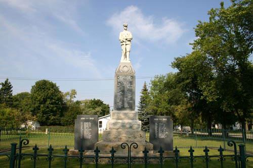
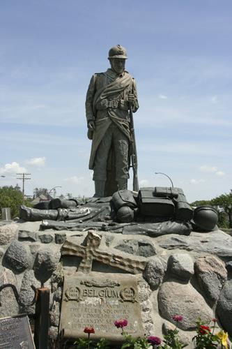
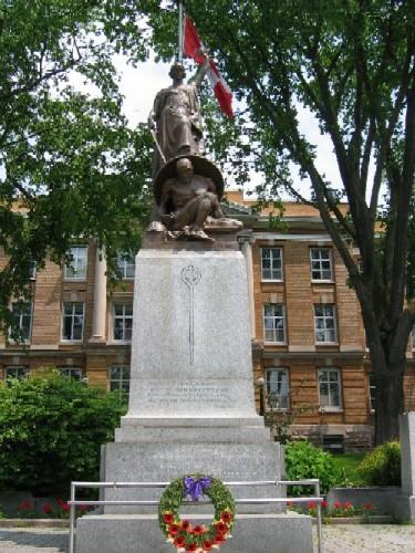
Principle view of the Manitou Cenotaph, Manitou, 2011.
Photo: Historic Resources Branch, Manitoba Culture, Heritage and Tourism, 2011
- Built
- 1921
- Recognized
- 2010
- By
- Local government
The register’s text, word for word
Description
The Manitou Cenotaph is a large and impressive war memorial, topped with a larger than life-size sculptural figure of a soldier that stands on the west side of the Town of Manitou's primary thoroughfare, Main Street. The municipal designation applies to the structure and the small fenced grounds in which it stands.
Heritage value
The Manitou Cenotaph is an exceptional example of the kind of affecting tributes that small Manitoba towns put up after World
War I to honour those who gave their lives during that conflict. Manitou's memorial is an especially fine example of the type, topped with a sculptural figure of a soldier at ease, staring forever into the distance. Erected in 1921, the frontispiece lists the names of battles, including Ypres, The Somme,
Lens and Hill 70. And the three sides grimly identify the scores of young men from Manitou and the Rural
Municipality of Pembina who never came home. Flanking black tablets feature the names of those who lost their lives in World War II. Marked by an elegant wrought iron fence, the memorial is a major feature on Manitou's prime thoroughfare.
SourceTown of Manitou By-law No. 8/2010, 15 October 2010.
Character‑defining elements
Key elements that define the site character of the Manitou Cenotaph include:
- the highly visible and strategic situation on the
west side of Main Street towards the very middle of that thoroughfare and across the street from the Manitou Town Hall
- the small grassed plot, in which the memorial is centrally sited, ringed by an elegant
wrought-iron fence
- the wide paved path leading from the street to the wrought-iron gates of the site
Key elements that define the physical character of the cenotaph include:
- the overall formal composition,
featuring a base of Manitoba limestone, consisting of five large steps with rough-cut edges, a tall black granite block with crisp edges, and culminating in a large sculpted military figure
- the opening inscriptions,
names of battles and names of the local dead from World War I inscribed on all sides of the black granite block
- the two flanking tablets, facing the street, of black granite and inscribed with the names of
local dead from World War II
End of the register’s text
Location
Manitou, Manitoba, Canada
49.24070° N, 98.53880° W
Get directions (opens in a new tab)Being on the register doesn’t make a place open to visitors. Many are private homes or businesses; please view them from the street.

Loading map…
Nearby
All 6 places in Manitou
Similar places
Places whose register descriptions are closest to this one.
From the Canadian Register of Historic Places, as last updated on December 12, 2025. The register’s text is shown word for word.