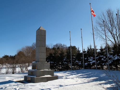
Overall view of the cenotaph
Photo: Town of Oromocto
- Built
- 1963
- Recognized
- 2009
- By
- Local government
The register’s text, word for word
Description
The Oromocto Cenotaph is a grey granite obelisk war memorial with several metal plaques attached, located in a grassed area on MacDonald Avenue in the Town of Oromocto.
Heritage value
The Oromocto Cenotaph is designated a Local Historic Place for its importance in highlighting the military history of citizens in the Oromocto region, as well as for its bold architectural design typical of World War cenotaphs throughout Canada.
Erected in 1963 by the citizens of Oromocto in a grassed park setting at the center of the town, the monument is a good example of the post-war stone monuments erected as memorials to the fallen soldiers of World Wars I and II, the Korean Conflict, and various Canadian Peacekeeping missions. Three bronze plaques are mounted at the base of the cenotaph listing these events, along with the names of the local fallen soldiers of Wars War I and II.
SourceTown of Oromocto, Town Office, Historic Places File, “Oromocto Cenotaph”
Character‑defining elements
The character-defining elements that describe the Oromocto Cenotaph include:
- the four meter-high obelisk design incorporating a smooth-faced cut grey granite rectangular shaft topped with a pyramid-shaped angled cap, all on a series of stepped rectangular plinths;
- the three cast bronze plaques attached to the front of the cenotaph, listing the dates and local victims of World Wars I and II, the dates of the Korean Conflict, and elements of the Canadian Peacekeeping missions;
- the larger park grounds surrounding the obelisk, with five flagpoles and shrub planting.
End of the register’s text
Location
MacDonald Avenue, Oromocto, New Brunswick, E2V, Canada
45.85089° N, 66.47430° W
Get directions (opens in a new tab)Being on the register doesn’t make a place open to visitors. Many are private homes or businesses; please view them from the street.

Loading map…
Nearby
All 3 places in Oromocto St. John's Anglican Church and Graveyard200 m · 1920
 George Brown House750 m
 Drill Hall1.6 km · Canadian Forces Base Gagetown/ Base des Forces canadiennes Gagetown · 1954
 Barrack Block - H231.9 km · Gagetown · 1958
 Christ Church Anglican National Historic Site of Canada3.1 km · Maugerville · 1856
 Junior Ranks Quarters3.3 km · Gagetown · 1958
Similar places
Places whose register descriptions are closest to this one.
From the Canadian Register of Historic Places, as last updated on December 12, 2025. The register’s text is shown word for word.