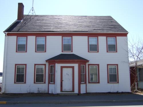
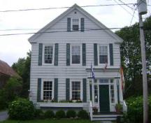
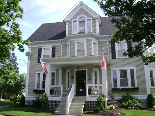
This photograph illustrates the building's 5 bay symmetrical façade, 2007
Photo: Town of St. Andrews
- Recognized
- 2007
- By
- Local government
The register’s text, word for word
Description
Snodgrass House is an early 19th-century, wooden, 2 1/2-storey Georgian residence. It is located on Water Street in St. Andrews.
Heritage value
Snodgrass House is designated a Local Historic Place for its architecture and for its association with the Snodgrass family.
Snodgrass House is recognized for its architecture. Built circa 1820, it displays the symmetrical five bay massing and medium pitched side-gabled roof that characterizes much of the Georgian architecture in St. Andrews.
Snodgrass House is also recognized for its association with the Snodgrass family. Isaac Snodgrass, a native of Ireland, obtained this circa 1820 home in 1853. He was a harness maker and carried on his trade at this residence. In 1869, Isaac's son, William, started his footwear store at this location. William's store sold medium and high grade boots, shoes, and rubbers for men, women, and children. The store also handled fancy and embroidery goods. William Snodgrass was one of the promoters of town incorporation and was the first mayor of St. Andrews (1903-1908). He was County Councillor for 8 years, Chairman of the Board of Health for 3 years, and at the time of his death, in 1913, was Collector of Customs. After his death his sister, Jennie Clark, continued the shoe store operation from this location until she sold the home in 1927.
SourceSt. Andrews Civic Trust - Charlotte County Archives, St. Andrews NB
Character‑defining elements
The character-defining elements that describe Snodgrass House include:
- orientation facing Water Street, St. Andrews' main street;
- window placement and proportions;
- massing, maintaining its symmetrical proportions;
- side-gable roof;
- central entranceway;
- straight roof-line, flush with walls;
- windows extend to the eaves.
End of the register’s text
Location
127 Water Street, St. Andrews, New Brunswick, E5B, Canada
45.07489° N, 67.05590° W
Get directions (opens in a new tab)Being on the register doesn’t make a place open to visitors. Many are private homes or businesses; please view them from the street.

Loading map…
Similar places
Places whose register descriptions are closest to this one.
From the Canadian Register of Historic Places, as last updated on December 12, 2025. The register’s text is shown word for word.