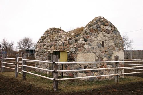
Primary elevations, from the northeast, of the Old Deloraine Bank Vault, Deloraine region, 2006
Photo: Historic Resources Branch, Manitoba Culture, Heritage, Tourism and Sport, 2005
- Built
- 1883
- Recognized
- 1993
- By
- Local government
The register’s text, word for word
Description
The Old Deloraine Bank Vault, completed in ca. 1883, is a small fieldstone enclosure on a farmyard near Deloraine. The municipal designation applies to structure on its footprint.
Heritage value
The Old Deloraine Bank Vault is the only remaining tangible link to the origins of Deloraine, one of the first communities established along the Boundary Commission Trail in western Manitoba. In 1883 A.P. and Frederick Thomas Stuart established a bank in the town and contracted local stonemason George Rickard to build the all-important vault. Deloraine was then conveniently situated in the vicinity of the area's first land titles office, but was moved eight kilometres northwest in 1886 when the railway arrived, leaving behind this stalwart thick-walled fieldstone structure.
SourceRural Municipality of Winchester By-law No. 93-017, October 13, 1993
Character‑defining elements
Key elements that define the site character of the Old Deloraine Bank Vault include:
- its location on the site of Old Deloraine, eight kilometres southeast of Deloraine, with its entrance facing east
Key exterior elements that define the structure's rugged character include:
- its short stout rectangular massing with a vaulted roof and raised ends
- the thick random rubble walls, with especially large stones at the corners, and roof of fieldstones of varying size and colour well anchored in mortar
- the entrance framed in thick planking with a fieldstone lintel
Key interior elements that define the structure's heritage character and banking function include:
- the open plan with ample headroom and storage space
- the unfinished dirt floor and plaster finish on parts of the ceiling
- functional details such as the metal support rods running from side to side and anchored on the outside by stout metal braces, and the mail chute on the lower south side
End of the register’s text
Location
Deloraine, Manitoba, R0M, Canada
49.15931° N, 100.40765° W
Get directions (opens in a new tab)Being on the register doesn’t make a place open to visitors. Many are private homes or businesses; please view them from the street.

Loading map…
Similar places
Places whose register descriptions are closest to this one.
From the Canadian Register of Historic Places, as last updated on December 12, 2025. The register’s text is shown word for word.