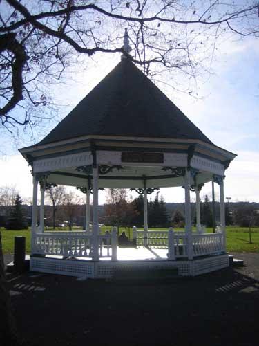
Wilmot Park bandstand, situated near Woodstock Road, in view of Old Government House
Photo: City of Fredericton
- Recognized
- 2008
- By
- Local government
The register’s text, word for word
Description
Wilmot Park, located at the west end of the Fredericton Town Plat, is bounded by Odell Avenue, Saunders Street, Rookwood Avenue, and Woodstock Road. This public park, covering an expanse of 8.5 hectares, overlooks Old Government House.
Heritage value
The heritage value of Wilmot Park is grounded in its early and continued use as a recreational area, while also memorializing the generosity of the park’s namesake, E.H. Wilmot. Wilmot Park, named in honour of benefactor Edward Henry Wilmot, was not a new park when it opened in 1895. The Prince of Wales had opened this “pleasure ground” during his 1860 Royal Tour. Interest in this park swiftly waned, perhaps due in part to its location at the edge of town. Overgrown and forgotten, this former park lay fallow for more than two decades.
E. H. Wilmot purchased the property from the Odell estate in 1894 with the intention that this land once again be transformed into a public park. Fredericton residents responded to the news of a park with considerable excitement and enthusiasm. Not only had Wilmot Park attracted those with leisure pursuits but it had also captured the attention of local builders.
The beauty of this new spot made the area attractive for development. In 1895, coincident with the opening of Wilmot Park, a new street, appropriately named Park Street (Odell Avenue), had been laid out with a number of available building lots. The establishment of Wilmot Park was directly responsible for the development of the western extremity of the town plat.
SourceCity of Fredericton, Historic Places, “Wilmot Park, 20 Woodstock Road”
Character‑defining elements
The character-defining elements that describe Wilmot Park include:
- manicured lawn and grounds;
- bandstand with commemorative plaque;
- monument to 1860 Prince of Wales opening of original pleasure ground;
- recreational facilities including playground equipment, wading pool, and tennis courts;
- continued use as a public park.
End of the register’s text
Location
20 Woodstock Road, Fredericton, New Brunswick, E3B, Canada
45.96351° N, 66.65685° W
Get directions (opens in a new tab)Being on the register doesn’t make a place open to visitors. Many are private homes or businesses; please view them from the street.

Loading map…
Similar places
Places whose register descriptions are closest to this one.
From the Canadian Register of Historic Places, as last updated on December 12, 2025. The register’s text is shown word for word.