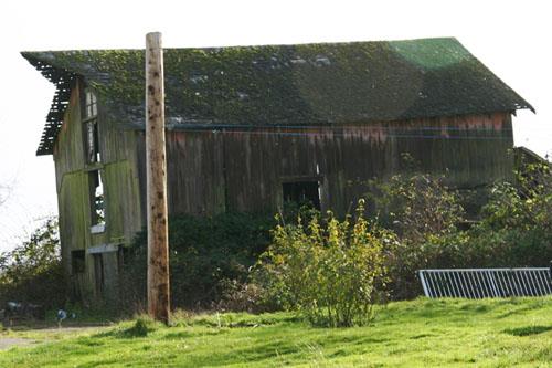
Sheldrake Barn
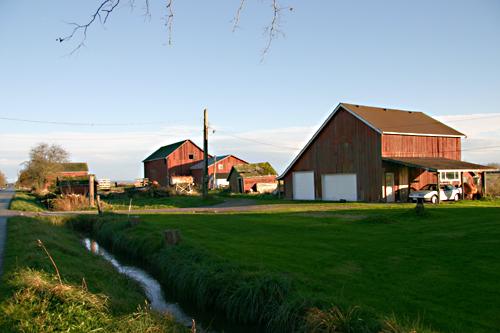
Photo: Corporation of Delta, 2008
- Recognized
- 2008
- By
- Local government
The register’s text, word for word
Description
Located in the rural agricultural area of Crescent Island in northwest Delta, the Sheldrake Barn is a small side-gabled structure with a shed and hipped roof addition. The barn is set back from the street, on the south side of River Road near Green Slough, to the west of the George Massey Tunnel.
Heritage value
The Sheldrake Barn is valued as an early agricultural outbuilding. It is located close to Green Slough, one of the natural waterways that facilitated the movement of goods and people, and linked the rural areas in Delta to Ladner village. Many of Delta’s barns have been lost due to the decline in traditional agricultural production, modern industrial and residential development, and general neglect, combined with the loss of their original agricultural context, and this barn stands as a reminder of Delta’s agricultural origins.
The Sheldrake Barn is also significant for its ties to pioneering Delta farming families. The larger property on which it stands, known as Riverside Farm, was acquired in 1893 by Henry Maxwell 'Harry' Vasey (1872-1960), a yeoman and farmer, after he moved here with his family from Lisgar, Québec. Vasey and his wife, Edith Grace (née Paull, 1873-1962), raised their family here. They began subdividing and selling off their property about 1910, and this parcel was acquired by English-born George Hubert Sheldrake (1884-1959) and his Scottish-born wife, Jennie Euphemia Sheldrake (1890-1960). The Sheldrakes, who married in Ladner in 1908, built this barn circa 1912. It is an intact example of an early cattle barn with an upper level hayloft, with a peaked roof that extends over the hayloft access.
SourceCorporation of Delta Planning Department
Character‑defining elements
Key elements that define the heritage character of the Sheldrake Barn include its:
- location in the rural agricultural community of Crescent Island, close to Green Slough
- deep setback from River Road
- continued use as an agricultural site
- agricultural form, scale and massing of the barn, as expressed by its rectangular plan, side-gabled roof with cedar shingles and extended peak roof on east side
- heavy timber frame structure with vertical plank siding
- windows such as the multi-paned double-hung wooden-sash window at the gable peak on the east end of building
End of the register’s text
Location
5734 River Road, Delta, British Columbia, Canada
49.10683° N, 123.06549° W
Get directions (opens in a new tab)Being on the register doesn’t make a place open to visitors. Many are private homes or businesses; please view them from the street.

Loading map…
Nearby
All 62 places in Delta
Similar places
Places whose register descriptions are closest to this one.
From the Canadian Register of Historic Places, as last updated on December 12, 2025. The register’s text is shown word for word.