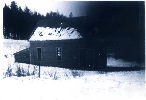
Image of the old Nerepis School, date unknown
Photo: Grand Bay-Westfield
- Recognized
- 2011
- By
- Local government
The register’s text, word for word
Description
The site of the former Nerepis School is located in a gully on the lower side of the Nerepis Road. The property, which overlooks the Nerepis River, has reverted to forest since the demolition of the building in the 1960s.
Heritage value
The significance of the former Nerepis School Site resides in its association with the population of the farming communities comprised by the Nerepis, Sagwa, and Brittain Road area. Beginning in the mid-1800s, grades 1-8 were taught in the one-room building, a structure typical of rural schools of the era. The school which was situated in close proximity to the former “Post Road,” a route which the local children would have taken daily to school.
The Nerepis School served the community until 1961, when several local schools were consolidated in a modern building in nearby Hillandale. The historic building fell into disrepair and was, eventually, demolished.
In spite of the loss of the school building, the property is still regarded as an important part of the community, particularly to those residents who remember the schoolhouse.
SourceGrand Bay Westfield Historic Places Files: Nerepis School Site
Character‑defining elements
The character-defining elements of the site include:
- its location within the communities known to local residents as Nerepis, Sagwa, and Brittain Road;
- the undisturbed context of the site with potential archaeological resources of the original school building.
End of the register’s text
Location
670 Nerepis Road, Grand Bay-Westfield, New Brunswick, E5K, Canada
45.39659° N, 66.29484° W
Get directions (opens in a new tab)Being on the register doesn’t make a place open to visitors. Many are private homes or businesses; please view them from the street.

Loading map…

Similar places
Places whose register descriptions are closest to this one.
From the Canadian Register of Historic Places, as last updated on December 12, 2025. The register’s text is shown word for word.