National Historic Site of Canada
Merrickville Blockhouse National Historic Site of Canada
Merrickville-Wolford, Ontario
Also known as Merrickville Blockhouse, Blockhaus-de-Merrickville
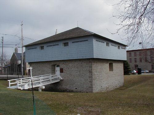
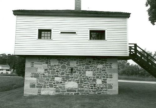
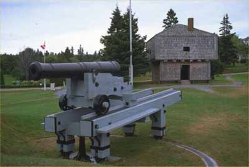
Corner view of the Merrickville Blockhouse, also showing vestiges of former defensive ditch around the building, 2004.
Photo: Parks Canada Agency / Agence Parcs Canada, 2004.
- Built
- 1832–1833
- Recognized
- 1939
- By
- Government of Canada
The register’s text, word for word
Description
Merrickville Blockhouse is a two-storey, masonry and timber defensive structure located on the banks of the Rideau Canal in the town of Merrickville Ontario.
Heritage value
Merrickville Blockhouse was designated a National Historic Site because it was considered a fine example of the best type of blockhouses erected for the defence of the Rideau Canal about 1832.
Its heritage value lies in its illustration of relatively large, 19th-century British designed blockhouse. Built in 1832-33, it is associated with the construction of the Rideau Canal waterway and the defence of Canada.
SourceHSMBC Minutes, May 1939, 1967; Commemorative Integrity Statement.
Character‑defining elements
- the blocky massing,
- its large size relative to other defensible structures along the canal,
- the tripartite design with a squat lower storey, overhanging upper storey, and steep hipped roof,
- the symmetrical design with central door and regular window openings,
- the functional design as a defensive structure with sparse door and window openings and plentiful gun slits,
- the fire resistant design with thick, vented stone walls on the basement and first storey,
- remaining original fabric in the lower storey,
- evidence of designed self-sufficiency, particularly related to the sub-division of space into provision storage, armament storage and barrack areas,
- vestiges of former defensive ditch around the building,
- the spacial relationship to the Merrickville Lockstation, particularly in the land-use allocation and circulation patterns,
- siting at the Merrickville Lockstation, with an unobstructed view up and down the Rideau waterway and down the Prescott and Brockville Roads.
End of the register’s text
Location
279 Saint Lawrence Street, Merrickville-Wolford, Ontario, K0G, Canada
44.91679° N, 75.83746° W
Get directions (opens in a new tab)Being on the register doesn’t make a place open to visitors. Many are private homes or businesses; please view them from the street.

Loading map…
 Merrickville Blockhousewithin 100 m · 1832
 Jakes-McLean Block100 m · 1861
 Foundry100 m · Merrickville · 1850
 Hutchins-Heroux Commercial Building150 m · Village of Merrickville-Wolford
 Aaron Merrick House750 m · Village of Merrickville-Wolford
 Defensible Lockmaster's House3.4 km · Rideau Canal National Historic Site of Canada / Lieu historique national du Canada du Canal-Rideau · 1838
Similar places
Places whose register descriptions are closest to this one.
From the Canadian Register of Historic Places, as last updated on December 12, 2025. The register’s text is shown word for word.