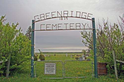
Contextual view, from the west, of the main gate of Green Ridge Cemetery, Dominion City area, 2006
Photo: Historic Resources Branch, Manitoba Culture, Heritage, Tourism and Sport, 2006
- Recognized
- 2002
- By
- Local government
The register’s text, word for word
Description
Green Ridge Cemetery is situated in a rural agricultural area about 15 kilometres east of Dominion City. The municipal designation applies to the cemetery's approximately 9,000-square-metre parcel of land.
Heritage value
Green Ridge Cemetery, established in 1879 on land donated by the Davison family, serves as a tangible link to the founders, past residents and history of three small settlements, Green Ridge, Newbridge and Woodmore, established in the Dominion City area in the 1870s by emigrants from Ontario. All three communities, which at their peak had a combined population of about 250, used Green Ridge Cemetery. Although little remains of these settlements, the cemetery, still active today, honours the hardship, hard work and perseverance of the area's pioneers.
SourceRural Municipality of Franklin By-law No. 05-02, July 9, 2002
Character‑defining elements
Key elements that define the heritage character of the Green Ridge Cemetery site include:
- the rural location on a generally flat, rectangular plot, surrounded by agricultural fields and accessed by a gravel road bordered by trees and shrubs
- the simple wood-post-and-wire fence, cemetery gateway and signage, also buffered by deciduous trees and shrubs and encompassing grassed and modestly treed grounds within
Key elements that define the cemetery's physical and functional character include:
- the burials and engraved grave markers, including their east-facing orientation
- the organization of grave markers into a loose grid
- the public access and continuing use
End of the register’s text
Location
Franklin, Manitoba, R0A, Canada
49.08789° N, 97.00643° W
Get directions (opens in a new tab)Being on the register doesn’t make a place open to visitors. Many are private homes or businesses; please view them from the street.

Loading map…
Nearby
All 9 places in Franklin
Similar places
Places whose register descriptions are closest to this one.
From the Canadian Register of Historic Places, as last updated on December 12, 2025. The register’s text is shown word for word.