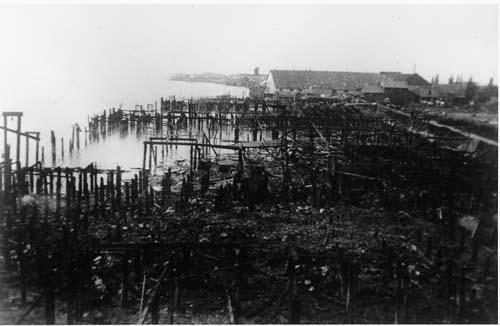
Photo: Richmond Archives photo no. 1977 1 242
- Construction
- 1899
- Reconnaissance
- 1992
- Par
- Administrations locales (C.-B.)
Le texte du répertoire, mot pour mot
Description
Scotch Pond consists of a large, man-made, rectangular water body, originally a slough, and the remains of wooden boardwalk pilings which run along the south edge of the pond, both situated within Garry Point Park along the tidal flats of Sturgeon Bank in the Steveston area of Richmond.
Valeur patrimoniale
Scotch Pond has heritage value because it is a landscape with historical associations to a number of the themes that permeate Richmond's history, including First Nations settlement, the Steveston canning and fishing industries, the Japanese boatbuilding tradition and modern fishing methods.
Originally a tidal slough, the area around Scotch Pond was the location of a year round Musqueam settlement occupied until the late 1890s, whose residents maintained a burial ground at the head of the Pond and accessed the fishing sites, clam beds, berry patches and other food plants.
Uniquely situated among the tidal flats of Sturgeon Bank at the end of a long boardwalk, the Scottish-Canadian Cannery was built by Malcolm and Windsor in 1899, taking advantage of the slough access to the Gulf of Georgia. Housing for cannery workers was constructed on pilings over the water. The cannery boardwalk was constructed in a line that followed a western extension of Chatham Street and provided land access to the cannery and its ancillary buildings which were constructed along its length. It is an early and rare example of an industrial development form which took advantage of the area's natural features.
Beginning operation in 1905, the Atagi Boatworks was located at the head of the slough, continuing the tradition of boatbuilding by skilled Japanese carpenters in Steveston. The Tsunematsu Atagi family was forced to leave the boatworks in the 1940s during internment.
After acquiring the cannery site around 1925 for use as a fishing station, the Canadian Fishing Company dredged the slough in the 1950s to create a moorage pond for their expanding fishing fleet. In keeping with the spirit of their predecessors, a group of fishermen have formed the Scotch Pond Heritage Cooperative Association to restore, maintain and manage the site as a traditional fish boat moorage.
SourceCity of Richmond Clerk's Department File #4200-02.
Éléments caractéristiques
Character defining elements of Scotch Pond include:
- The remains of the wooden pilings along the south edge of the Pond which originally supported the boardwalk connecting the Scottish Canadian Cannery to Steveston
- The Scotch Pond as it exists today, as a geometrically shaped water body connected to the Gulf of Georgia and including a small, rectangular wooden building and wooden boat docks
- The traditional use of this area for activities related to the fishing industry by the Scotch Pond Heritage Cooperative
- The setting which is comprised of the natural landscape of the Sturgeon Banks tidal flats and Garry Point
Fin du texte du répertoire
Emplacement
49.12673° N, 123.19772° W
Itinéraire (s’ouvre dans un nouvel onglet)L’inscription au répertoire ne rend pas un lieu accessible au public. Beaucoup sont des résidences ou des commerces privés; admirez-les depuis la rue.

Chargement de la carte…
À proximité
Les 35 lieux de Richmond


Lieux semblables
Les lieux dont la description du répertoire se rapproche le plus de celle-ci.
 No. 1 Road PumpstationRichmond, Colombie Britannique
 Brighouse Homestead and Heritage TreesRichmond, Colombie Britannique
 Ladner's LandingDelta, Colombie Britannique
 Beaver Pond Municipal Heritage Site
 Lieu historique national du Canada du Chantier-Naval-BritanniaRichmond, Colombie Britannique
 Butedale CanneryButedale, Colombie Britannique
Tiré du Répertoire canadien des lieux patrimoniaux, dans sa dernière mise à jour du 12 décembre 2025. Le texte du répertoire est reproduit mot pour mot.