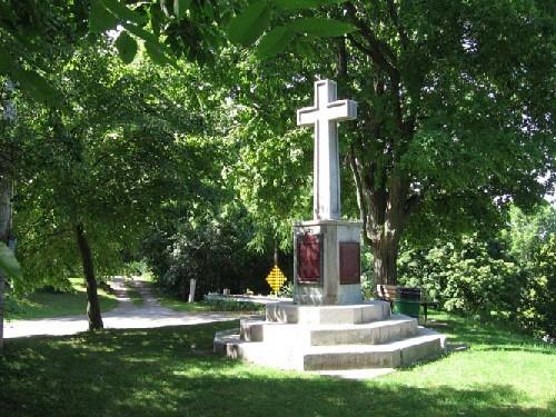
View of Cliff Site National Historic Site of Canada, showing the monument, consisting of a cross on a pedestal resting on octagonal steps, which represents the form and symbolism of the original cross raised by Dollier and Bréhant, 2005.
Photo: Parks Canada Agency / Agence Parcs Canada, 2005.
- Recognized
- 1919
- By
- Government of Canada
The register’s text, word for word
Description
Cliff Site National Historic Site of Canada, located on Brant Hill in Port Dover, Ontario, overlooks Highway 6, along the north shore of Lake Erie. The site is marked by a large memorial cross. A cross on a pedestal resting on octogonal steps, this monument bears a Historic Sites and Monuments Board of Canada plaque, as well as a secondary plaque, commemorating a 1670 cross raising of which there are no extant remains. Official recognition refers to the current site of the cross surrounded by a five metre radius.
Heritage value
Cliff Site was designated a national historic site of Canada in 1920 because:
- On March 23, 1670, two Sulpician priests, François Dollier de Casson and René de Brehant de Galinée, laid claim in the name of France to the north shore of Lake Erie, an important episode in the development of the Canadian nation.
On 6 July 1669, French missionaries François Dollier de Casson and René Bréhent de Galinée departed from Montréal as part of an expedition into the interior led by Robert Cavalier de La Salle. Part of an original party of twenty-two Europeans and Algonkian interpreters, Dollier and Galinée split from the party shortly after travelling through present-day Hamilton. Dollier and Galinée were accompanied by seven men and three canoes and, in late October 1669, they set up a winter camp at the present day community of Port Dover. Having chosen the site for its aesthetic appeal and abundant food sources, Dollier and Galinée declared this area territory of France in the name of King Louis XIV. On 23 March 1670, three days prior to the group’s departure, a large cross was erected with the arms of France, thereby marking an important episode in the development of the Canadian nation.
SourceHistoric Sites and Monuments Board of Canada, Minutes, 1920, December 2008.
Character‑defining elements
Key elements contributing to the heritage value of this site include:
- its location in Port Dover, along the north shore of Lake Erie;
- its setting on Brant Hill overlooking Highway 6, and monument, consisting of a cross on a pedestal resting on octagonal steps, which represents the form and symbolism of the original cross raised by Dollier and Bréhant;
- the integrity of any surviving or as yet unidentified archaeological remains, which may be found within the site and related to the original cross-raising;
- viewscapes from the site to the surrounding community of Port Dover.
End of the register’s text
Location
Norfolk, Ontario, N0A, Canada
42.78558° N, 80.19608° W
Get directions (opens in a new tab)Being on the register doesn’t make a place open to visitors. Many are private homes or businesses; please view them from the street.

Loading map…
Nearby
All 4 places in Norfolk Lighthouse350 m · Port Dover
 Port Dover West Pier Lighthouse650 m · Port Dover · 1850
 Lynnwood/Campbell-Reid House National Historic Site of Canada11 km · 1850
 Nanticoke National Historic Site of Canada12 km · Nanticoke
 Edmondson-Weaver House12 km · Haldimand County
 Jeffrey Residence12 km · Haldimand County
Similar places
Places whose register descriptions are closest to this one.
 Fort Sainte Marie II National Historic Site of CanadaChristian Island, Ontario
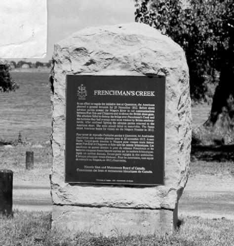 Frenchman's Creek National Historic Site of CanadaFort Erie, Ontario
 Port Stanley National Historic Site of CanadaCentral Elgin, Ontario
- Saint-Louis Mission National Historic Site of CanadaVictoria Harbour, Ontario
 Fort Erie National Historic Site of CanadaFort Erie, Ontario
 Battlefield of Fort George National Historic Site of CanadaNiagara-on-the-Lake, Ontario
From the Canadian Register of Historic Places, as last updated on December 12, 2025. The register’s text is shown word for word.