Municipal Heritage Designation (Part IV)
Brown/McCaughtery House
City of Mississauga, Ontario
Also known as Brown-McCaughtery Estate, 1614 Wintergrove Gardens
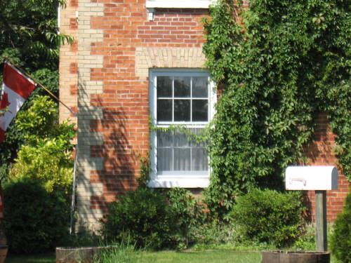
Of note is the yellow brick lintel above the square headed, six over six, double hung window.
Photo: Beatrice Tam, 2008.
- Recognized
- 1983
- By
- Local government
The register’s text, word for word
Description
The Brown/McCaughtery House is located at 1614 Wintergrove Gardens on the south side of Wintergrove Gardens, west of Queen Street South, in the City of Mississauga. The two storey brick structure was constructed circa 1865.
The property was designated by the City of Mississauga in 1983 for its heritage value under Part IV of the Ontario Heritage Act (By-law 898-83).
Heritage value
The Brown/McCaughtery House is a particularly fine example of a farmhouse design popular in Ontario in the late 1860s. The farmhouse design became popular after the magazine, The Canada Farmer, recommended it in 1865. This style is characterized by its hip roof, two storey three bay facade with a central projecting frontispiece and polychromatic brick trim in the quoins. Though typical in form, the Brown/McCaughtery Estate is distinct in its details, with its lacy bargeboard and its Tuscan Gothic window motif in the frontispiece. The attached drive shed, with its polychromatic brick patterning and its arched openings, provides additional interest.
SourceCity of Mississauga, By-law 898-83.
Character‑defining elements
Character defining elements that contribute to the heritage value of the Brown/McCaughtery House include its:
- two storey brick exterior
- hip roof
- three bay facade
- central projecting frontispiece
- central gable
- lacy bargeboard
- paired, round headed, four over four windows in central bay
- square headed, six over six, double hung windows
- yellow brick quoins
- yellow brick radiating voussoirs
- yellow brick lintels
- cornice with panelled frieze
- lighted transom
End of the register’s text
Location
1614, Wintergrove Gardens, City of Mississauga, Ontario, Canada
43.58569° N, 79.70142° W
Get directions (opens in a new tab)Being on the register doesn’t make a place open to visitors. Many are private homes or businesses; please view them from the street.

Loading map…

Similar places
Places whose register descriptions are closest to this one.
From the Canadian Register of Historic Places, as last updated on December 12, 2025. The register’s text is shown word for word.