Local Historic Place (municipal)
Pines Conservation Park
Cambridge-Narrows, New Brunswick
Also known as Sypher Property, Propriété Sypher, Washademoak Lodge and Cabins
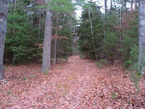
This image shows a trail in the Pines Conservation Park during the fall
Photo: Village of Cambridge-Narrows
- Recognized
- 2009
- By
- Local government
The register’s text, word for word
Description
The Pines Conservation Park is a parcel of land measuring more than 5.5 hectares in Cambridge-Narrows on the eastern bank of Washademoak Lake facing on Route 695 (Bridge Drive) immediately to the left after crossing the bridge from west to east.
Heritage value
The Pines Conservation Park is designated a Local Historic Place for its conservation of old growth Acadian forest and for its unique current use as a green space in a rural village.
The park is a particularly scenic parcel of land on the shore of Washademoak Lake which is characterized by rugged rocky outcrops and a relatively undisturbed remnant of old growth Acadian forest. This is a mixed forest with large old pine trees, oaks and a good variety of shrubs, vines and vascular plants typical of the area; 31 representative species in all. Through the first half of the 20th century, the former residence on the land operated as an inn with tourist cabins spaced throughout the property. It was purchased by the village in 2005 to secure public land as “green space” on the lakeshore for long-term future use by the community. From a heritage point of view, this is a very progressive step for a small rural village. The Village Council is to be commended for their appropriate and environmentally sensitive uses for the park. Their inspiration in purchasing the land was Frederick Law Olmstead’s contention that every village, town and city needs adequate green space in its plan.
SourceQueens County Heritage Archives – Cambridge-Narrows Historic Places files
Character‑defining elements
The charcter-defining elements of the Pines Conservation Park include:
- dozens of large old pine trees;
- rugged rocky shore;
- marvelous vistas of Washademoak Lake with access to the lake for swimming;
- old growth Acadian forest;
- public land dedicated to education and conservation;
- deer and other native animal species.
End of the register’s text
Location
1307 Bridge Drive, Cambridge-Narrows, New Brunswick, E4C, Canada
45.82981° N, 65.94825° W
Get directions (opens in a new tab)Being on the register doesn’t make a place open to visitors. Many are private homes or businesses; please view them from the street.

Loading map…
Similar places
Places whose register descriptions are closest to this one.
From the Canadian Register of Historic Places, as last updated on December 12, 2025. The register’s text is shown word for word.