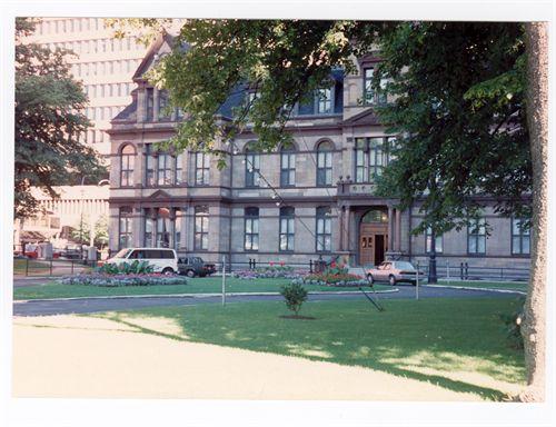
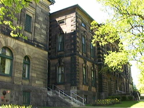
Grand Parade looking towards City Hall, Halifax, 2003.
Photo: HRM Planning and Development Services, Heritage Property Program, 2003.
- Built
- 1749
- Recognized
- 1981
- By
- Local government
The register’s text, word for word
Description
The Grand Parade is a rectangular civic space in Downtown Halifax, NS, established in 1749. The historic place was laid down as a parade square and reserved for military drills. On the south end of Parade Square stands St. Paul's Anglican Church and on the north end is Halifax City Hall. Municipal designation applies to land and the structures (not the buildings) on it.
Heritage value
Grand Parade is valued as Halifax's oldest area of public open space and its association with the founding of Halifax. It was laid out and reserved at the time of settlement in 1749. With St. Paul's Church at one end and City Hall at the other, it has long been a symbolic centre for public assembly. The Parade grounds were originally laid out by city planners as a public space where civic affairs were conducted and a place for the military to drill. Since its founding many events such as performances, leisure activities, religious gatherings, and public ceremonies have been held there. The Cenotaph was erected in the center of the square as a memorial to the 1,360 Haligonians gave their lives during the First and Second World Wars and the Korean Conflict.
The location of the Grand Parade is valued for being in the ‘heart’ of downtown. It is part of the original plans for Halifax, between the Halifax Waterfront and the Halifax Citadel. The Grand Parade was built to be easily accessed by Halifax residents as well as surrounding areas like Dartmouth and Bedford. Ultimately, Downtown Halifax has developed around the property and buildings on the Grand Parade. Today it continues to serve as the center of the city and hosts numerous events, gatherings and ceremonies.
Grand Parade is also valued as a planned space for the gathering of large numbers of people in the centre of the city. A wall surrounding Grand Parade was later built that included a comfort station, which turned into a police patrol station until 1952. As part of the improvements, a performers circle was built beside the Cenotaph. In later years changes were made, including an 1890s undertaking to beautify the space which saw the addition of a twenty-foot wide carriage drive beginning at Barrington Street entrance continued in a circular form to the front of City Hall and back to Barrington Street. There is a nine-foot walkway placed along the Barrington Street wall and a narrow one on the Barrington Street side. The space is also the location of the Cenotaph. Views of the Cenotaph in the Grand Parade can be seen from the surrounding streets. In 1978 a plaque representing the rededication of the Grand Parade as the central gathering place for the people of the City of Halifax was erected. The flag pole in the square is made of British Columbia fir.
SourceHRM Heritage File 1790 Argyle Street, Grand Parade, found at HRM Planning and Development Services, Heritage Property Program, 6960 Mumford Road, Halifax, Nova Scotia.
Character‑defining elements
The character-defining elements of the Grand Parade include:
- continued use as a space for the gathering of large numbers of people in the centre of the city;
- stone wall surrounding Grand Parade;
- performers circle beside Cenotaph;
- twenty-foot wide carriage drive beginning at Barrington Street entrance continued in a circular form to the front of City Hall and back to Barrington Street;
- nine-foot walkway placed along the Barrington Street wall and a narrow one on the Barrington Street side;
- Cenotaph in central location;
- plaque re: rededication of the Grand Parade as the central gathering place for the people of the City of Halifax;
- flag pole made of British Columbia fir.
End of the register’s text
Location
1790 Argyle Street, Halifax, Nova Scotia, B3J, Canada
44.64821° N, 63.57489° W
Get directions (opens in a new tab)Being on the register doesn’t make a place open to visitors. Many are private homes or businesses; please view them from the street.

Loading map…
 Halifax City Hall National Historic Site of Canadawithin 100 m · 1887
 Macara-Barnstead Buildingwithin 100 m · 1825
 St. Paul's Anglican Church National Historic Site of Canadawithin 100 m · 1750
 St. Paul's Anglican Churchwithin 100 m · 1750
 G.M. Smith Building100 m · 1893
 1724 Granville Street100 m · 1900
Similar places
Places whose register descriptions are closest to this one.
From the Canadian Register of Historic Places, as last updated on December 12, 2025. The register’s text is shown word for word.