National Historic Site of Canada
Corossol National Historic Site of Canada
Sept-Îles, Quebec
Also known as Corossol, Wreck of the Corossol, Épave du Corossol
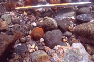
Detailed view of the Corossol, showing a cannon ball.
Photo: Agence Parcs Canada / Parks Canada Agency.
- Recognized
- 1995
- By
- Government of Canada
The register’s text, word for word
Description
Corossol National Historic Site of Canada is an underwater site situated south of Île Manowin, near Corossol Island near the entrance of Baie des Sept Îles, Quebec. Its name refers to the ship belonging to the King of France, which sank in a storm in 1693 while en route to France. The site is comprised of a number of cannon, as well as several associated artifacts. The designated site encompasses a 200-metre radius around a point on the seabed.
Heritage value
Corossol was designated a national historic site of Canada in 1995 because:
- of its potential for contributing greatly to our knowledge of life in New France during the period.
The scientific value of the wreck of the Corossol is based on its rarity and its antiquity. Its remains are to this date the only ones in Canada that have been confirmed to date as being from the wreck of a 17th-century French vessel. It also serves as a significant contribution to the commemoration of Canada’s little-known national maritime heritage.
The historical value of Corossol derives from its potential as a source of information on the material culture of New France in the 17th century. Documentary evidence indicates that the French King’s vessel arrived in the colony in August 1693, and departed in October of the same year with fur pelts and passengers returning to France. A few days later it struck a shoal and sank, and its cargo was scattered along the coast. A salvage expedition in May 1694 was partly successful. Even though the old witness reports from survivors did not enable the wreck to be accurately located, the site was identified in 1990 from period documents, records of the salvage expedition, and from the discovery of such significant items as a 1691 French coin and various military artifacts attesting to the military role of the ship. Local place names also contributed to the identification of the wreck, as the remains were located between Île du Corossol and Île Manowin, previously known respectively as “Carroussel du Large” or “Petit Carroussel” and “Carroussel de terre” or “Grand Carroussel”.
SourceHistoric Sites and Monuments Board of Canada, Minutes, 1995, 2007.
Character‑defining elements
Key elements that contribute to the heritage character of the site include:
- its location on the seabed, between Corossol and Manowin Islands, near the entrance of Baie des Sept Îles;
- its setting matching the local place names and historic sources;
- the continued association of the site with archaeological artifacts in situ or removed for research, and those in storage and on display to the public, consistent with the period and origin of the vessel including: a French silver demi-écu coin dating from 1691; cannons of characteristic shape with very distinctive moulded elements; a lead seal used to bind a bale of fur pelts, marked with the word "Canada", a crest with three fleur-de-lis and a reference to the Roi Soleil, a characteristic French mark; a pot handle whose shape is reminiscent of the Saintongeais cooking pots from France and those sold by a Quebec City merchant named Paradis in the late 17th century; and, hand grenades with fuses consistent with French artillery standards of the period;
- the continued association of the site with archaeological artifacts in situ or removed for research, and those in storage and on display to the public, that would typically be found on a French King’s vessel: grapeshot ammunition of various sizes; hand grenades, some intact and others incomplete; one bar shot; and cannonballs.
- the integrity of any surviving or as yet unidentified archaeological remains associated with the wreck, which may be found within the site in their original placement and extent, and in a good state of preservation.
End of the register’s text
Location
Sept-Îles, Quebec, Canada
50.09861° N, 66.38453° W
Get directions (opens in a new tab)Being on the register doesn’t make a place open to visitors. Many are private homes or businesses; please view them from the street.

Loading map…
Similar places
Places whose register descriptions are closest to this one.
 Wreck of the Elizabeth and Mary National Historic Site of CanadaBaie-Trinité, Quebec
 Martinique Bay Provincial Historic SiteConche, Newfoundland And Labrador
 Bay Bulls Harbour Provincial Historic SiteBay Bulls, Newfoundland And Labrador
 Hamilton and Scourge National Historic Site of CanadaLake Ontario, Ontario
 Battle of the Restigouche National Historic Site of CanadaPointe-à-la-Croix, Quebec
 Coteau-du-Lac National Historic Site of CanadaCoteau-du-Lac, Quebec
From the Canadian Register of Historic Places, as last updated on December 12, 2025. The register’s text is shown word for word.