National Historic Site of Canada
Chiefswood National Historic Site of Canada
Six Nations Grand River Reserve, Ontario
Also known as Chiefswood
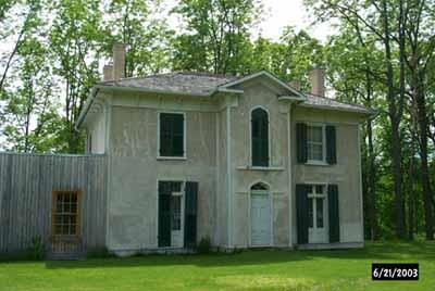
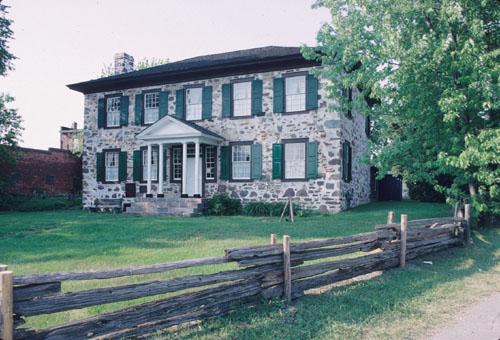
Corner view of Chiefswood, showing the front elevation and the main entrance, 2003.
Photo: Parks Canada Agency/ Agence Parcs Canada, 2003.
- Built
- 1853–1856
- Recognized
- 1953
- By
- Government of Canada
The register’s text, word for word
Description
Chiefswood is a small gem of an Italianate villa set in a picturesque treed landscape on the banks of the Grand River in the heart of the Six Nations Grand River Territory, in Ontario. Its location is key to its historic meaning as the home of the Johnson family, especially poet E. Pauline Johnson. The formal recognition refers to the interior and exterior of the house.
Heritage value
Chiefswood National Historic Site of Canada was designated because it speaks to the Johnson family's role as intermediaries between Aboriginal and non-Aboriginal cultures.
Built between 1853 and 1856 for Six Nations Chief George H.M. Johnson (1816 - 1884), Chiefswood was the birthplace of poet Emily Pauline Johnson and the Johnson family home until George Johnson's death in 1884. Johnson was prominent socially and politically, serving as official government interpreter, thus bridging both the British colonial and First Nations worlds. He built his home on farmland he purchased along the Grand River, close to the Anglican mission church near Tuscarora (Middleport). While not the only mansion built by First Nations families during the nineteenth century, Chiefswood is the only one of such a grand scale and architectural sophistication known to have survived.
SourceHistoric Sites and Monuments Board of Canada, Minutes, June 1992.
Character‑defining elements
Aspects of Chiefswood that contribute to its heritage value include those elements which speak to the Johnson’s family role as intermediaries between Aboriginal and non-Aboriginal cultures, namely:
— the location of the house on the Six Nations Grand River Territory;
— its intimate relationship with its natural setting, the river and the surrounding landscape;
— its use of the Italianate architectural vocabulary as a sophisticated and fashionable manner illustrated by the symmetrical elevation, two-storey volume with truncated hip roof and chimneys, deep bracketed eaves, stucco finish, sash and French windows, classically inspired frontispiece, and standard, centre-hall floor plan with surviving, classically inspired trim.
End of the register’s text
Location
Highway 54, Six Nations Grand River Reserve, Ontario, N0A, Canada
43.10111° N, 80.09445° W
Get directions (opens in a new tab)Being on the register doesn’t make a place open to visitors. Many are private homes or businesses; please view them from the street.

Loading map…
Nearby
 Chiefswood200 m · Six Nations of the Grand River Territory · 1991
 McKinlay-McGinty House7 km · City of
 Gibson-Alderson House11 km · Haldimand County
 Old Caledonia Mill12 km · Haldimand County · 1853
 Her Majesty's / St. Paul's Chapel of the Mohawks National Historic Site of Canada12 km · Brantford · 1785
 Toll House12 km · Haldimand County · 1874
Similar places
Places whose register descriptions are closest to this one.
 Macdonell-Williamson House National Historic Site of CanadaChute-à-Blondeau, Ontario
 Homewood National Historic Site of CanadaMaitland, Ontario
 Sir John Johnson House National Historic Site of CanadaWilliamstown, Ontario
 Ermatinger Old Stone HouseSault Ste. Marie, Ontario
 Christ Church, Her Majesty's Chapel Royal of the Mohawk National Historic Site of CanadaDeseronto, Ontario
 Ermatinger House National Historic Site of CanadaSault Ste. Marie, Ontario
From the Canadian Register of Historic Places, as last updated on December 12, 2025. The register’s text is shown word for word.