National Historic Site of Canada
Cartier-Brébeuf National Historic Site of Canada
Québec, Quebec
Also known as Cartier-Brébeuf
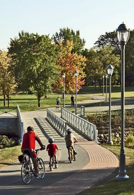
General view of Cartier-Brébeuf, showing the landscaped surface area of 6.8 hectares laid out in an informal manner.
Photo: Parks Canada Agency / Agence Parcs Canada.
- Recognized
- 1958
- By
- Government of Canada
The register’s text, word for word
Description
Cartier-Brébeuf National Historic Site of Canada is a 6.8-hectare park located on the north bank of the Saint Charles River in the Limoilou district of Québec City. Originally located near the Iroquoian village of Stadacona, the site commemorates the winter quarters of Jacques Cartier and his companions in 1535-1536, and the first Jesuit missionary residence in Quebec constructed during the period 1625-1626. Today, grass, selective planting, mature trees, and walking and cycling paths characterize the landscaped site. Other features include an exhibit on the three voyages of the explorer Jacques Cartier, an interpretation kiosk on the Jesuits, a longhouse surrounded by a stake palisade, and a number of commemorative monuments, one of which represents the figures of Jacques Cartier and the great chief Donnacona of Stadacona. The designation refers to the park in the shape of a horseshoe encircling a reservoir.
Heritage value
Cartier-Brébeuf was designated a national historic site of Canada to commemorate:
- the winter quarters of Jacques Cartier and his companions in 1535-1536 near the Iroquois village of Stadcona; and
- the establishment of the first Jesuit missionary residence at Québec in 1625-1626.
The heritage value of Cartier-Brébeuf National Historic Site of Canada resides in the sense of place its location and historic monuments evoke. This historic park originated in 1889 when the Saint Jean Baptiste Society inaugurated a monument erected by the Cercle Catholique de Québec to commemorate it as the site of Jacques Cartier’s winter quarters and Notre-Dame-des-Anges, the first Jesuit residence at Québec. Since the missionary Jean de Brébeuf visited this residence, the park was called Cartier-Brébeuf. It was transferred to the federal government in 1957-58 as a national historic site of Canada. In 1971, a reservoir was created in the park as an interpretation device that recalls the former confluence between the Saint Charles River and the Lairet, a river that is now channelled underground.
SourceHistoric Sites and Monuments Board of Canada, Minutes, 1957; Commemorative Integrity Statement.
Character‑defining elements
Key elements that contribute to the heritage character of the site include:
- the park’s location on the banks of the Saint Charles River north of downtown Quebec City;
- the park’s setting in the Limoilou District named after Jacques Cartier’s birthplace in France;
- the landscaped surface area of 6.8 hectares laid out in an informal manner with grass, selective planting, mature trees, bicycle routes, pathways, picnic areas and observation points;
- the reservoir also known as the artificial pond that evokes the confluence of the Lairet and Saint Charles Rivers:
- the individual monuments, their location, materials and texts which have historical associations for the city, province or nation;
- its visual and landscape character including the unimpeded viewscapes within the park, and those viewscapes from the park to the Saint Charles River;
- the integrity and materials of any undiscovered surviving archaeological remains, features and artifacts in their original placement and extent relating to the winter quarters of Jacques Cartier and his companions in 1535-1536, and the first Jesuit missionary residence.
End of the register’s text
Location
175 de l'Espinay Street, Québec, Quebec, G1L, Canada
46.82531° N, 71.23960° W
Get directions (opens in a new tab)Being on the register doesn’t make a place open to visitors. Many are private homes or businesses; please view them from the street.

Loading map…
Nearby
All 194 places in Québec- Hôpital-Général de Québec Monastery National Historic Site of Canada1.3 km · 1671
 Hôpital-Général de Québec Cemetery National Historic Site of Canada1.4 km · 1759
 École Saint-Charles-de-Hedleyville1.4 km
 Hôpital général de Québec1.4 km · Notre-Dame-des-Anges
 Moulin à vent de l'Hôpital-Général-de-Québec1.5 km · 1730
 La Fabrique National Historic Site of Canada1.8 km · 1871
Similar places
Places whose register descriptions are closest to this one.
 Hochelaga National Historic Site of CanadaMontréal, Quebec
 Maison Cartier National Historic Site of CanadaMontréal, Quebec
 Pointe-du-Buisson National Historic Site of CanadaBeauharnois, Quebec
 Caughnawaga Presbytery National Historic Site of CanadaKahnawake, Quebec
 Fort St-Louis National Historic Site of CanadaKahnawake, Quebec
 Old Wendake Historic District National Historic Site of CanadaWendake, Quebec
From the Canadian Register of Historic Places, as last updated on December 12, 2025. The register’s text is shown word for word.