National Historic Site of Canada
Buxton Settlement National Historic Site of Canada
Buxton, Ontario
Also known as Buxton Settlement, Établissement Buxton, Elgin Settlement
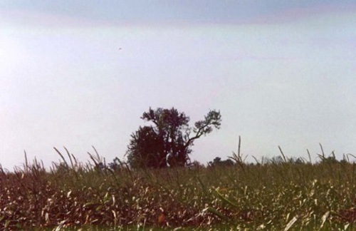
Buxton Settlement Pear Tree – site of the first Homecoming Picnic in 1924
Photo: Parks Canada | Parcs Canada
- Recognized
- 1999
- By
- Government of Canada
The register’s text, word for word
Description
The Buxton Settlement National Historic Site of Canada is a cultural landscape of some 4,680 hectares. It is a primarily agricultural landscape, comprised of flat, worked fields defined by deep drainage ditches and a grid of intersecting roads. Homesteads are scattered throughout the settlement area including its two hamlets, South and North Buxton, which also contain important religious, educational and cultural institutions associated with the settlement's founding by Underground Railroad refugees.
Heritage value
Buxton Settlement National Historic Site of Canada was designated because:
- this cultural landscape, through the retention of land-use patterns and built resources, speaks to the successful realization of the block or planned refugee settlement in Canada;
- the cultural landscape continues as a living memorial to its founders and to the courage of every Underground Railroad refugee who took their life in their hands and chose Canada as their home.
The heritage value of this site resides in the site's illustration of a successful Underground Railroad refugee block settlement through the survival of land-use patterns and associated built resources.
Established as the Elgin Settlement at Buxton, Ontario, the Buxton Settlement survives today as a distinct cultural landscape, one that continues to function as a community while preserving tangible survivals from its historic past. It was founded in 1849 by Irish Presbyterian Minister, Reverend William King and 15 former American slaves who, with other Underground Railroad (UGRR) refugees and abolitionists, purchased a 4,680 hectare tract of land as a joint stock company. Settlers cleared the land and established farms on 50-acre (202,342 square metre) plots which they purchased over time. By 1859, the settlement reached its peak population of over 1,000 residents served by three integrated schools, two temperance hotels, a general store, a post office, a sawmill, a brickyard, a grist mill and a pearlash factory. In 1873, its objectives achieved, the company was disbanded but the community survived.
SourceHistoric Sites and Monuments Board of Canada, Minute, March 1998; Commemorative Integrity Statement, 2002.
Character‑defining elements
Elements which characterize the heritage value of the Buxton Settlement as an UGRR block settlement include:
- the agricultural land-use patterns expressed through open spaces with field plots demarcated by hedgerows, lilies, tree lines, or differing planting patterns and remnants of the original planned settlement seen in surviving 50-acre (20.2 hectares) plots
- the road grid following originally surveyed north-south roads and east-west concession lines
- the settlement nodes of North and South Buxton characterized by low-density, small-scale housing and modest institutional buildings set amongst outbuildings, lawns, and trees
- scattered homesteads along roadways
- scattered woodlots
- system of drainage ditches parallelling the road grid
- graveyards and cemeteries associated with churches and/or homesteads
- surviving landscape elements including North Buxton mill pond, archaeological remnants of former industrial buildings, the first railway line, tramway and lakeshore loading site
- the sentinel Pear Tree associated with traditional homecoming in North Buxton
Built Resources: Churches
- rectangular massing under front-gabled, pitched roof
- wood-frame construction
- open plan
- minimal decorative elaboration
- steeple and Freedom Bell at St. Andrew's United Church.
Built Resources: Houses
- modest scale
- vernacular design and craftsmanship
- predominance of wood construction materials
- survival of original one-and-a-half-storey, four-room Ontario cottage (two-up, two-down) of log or frame construction with 30 foot (9.14 metre) setback from the road.
Built Resources: Former Raleigh Schoolhouse #13
- rectangular massing under front-gabled, pitched roof
- wood-frame construction and sheathing
- open plan with cloak room.
Built resources: Former Railway Station
- rectangular, single-storey massing
- wood-frame construction.
End of the register’s text
Location
Buxton, Ontario, Canada
42.30637° N, 82.22107° W
Get directions (opens in a new tab)Being on the register doesn’t make a place open to visitors. Many are private homes or businesses; please view them from the street.

Loading map…
Nearby

Similar places
Places whose register descriptions are closest to this one.
 Beechey Island Sites National Historic Site of CanadaBeechey Island, Nunavut
 Sandwich First Baptist Church National Historic Site of CanadaWindsor, Ontario
 Fort Hope National Historic Site of CanadaHope, British Columbia
 Griffin House National Historic Site of CanadaHamilton, Ontario
 Burlington Heights National Historic Site of CanadaHamilton, Ontario
 York Factory National Historic Site of CanadaYork Factory, Manitoba
From the Canadian Register of Historic Places, as last updated on December 12, 2025. The register’s text is shown word for word.