Community Heritage Register
Richmond Rod and Gun Club
Richmond, British Columbia
Also known as Richmond Methodist Church Hall
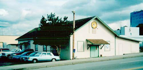
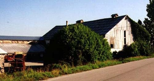
Exterior view of the Richmond Rod and Gun Club building, 2000
Photo: Julie MacDonald Heritage Consulting
- Built
- 1891
- Recognized
- 2003
- By
- Local government
The register’s text, word for word
Description
The Richmond Rod and Gun Club building is a large, one storey, rectangular building with a front gable roof, simple detailing and a shed-roofed addition on the east side.
Heritage value
This structure has heritage value for its historical association to the Richmond Mission Methodist Church, and as the only remaining structure of the original three building complex, consisting of the church, stable and manse, which was a prominent religious and social centre for residents of Richmond's Bridgeport area. Converted in 1931 for use as a community hall from its original use as the church stable, the building's location on the riverfront is significant. In the early part of the twentieth century, prior to road construction, transportation to and from various points in Richmond was conducted mainly by water.
The church manse has since been demolished and the Richmond Mission Methodist Church (later the Richmond United Church) was relocated to Richmond's Minoru Park and renamed the Minoru Chapel in the 1960s.
The Richmond Rod and Gun Club building is also significant for its early construction date, which marks the beginnings of the Methodist Church in Richmond, and for its simple rectangular shape and size, reflecting its use as a stable and later as a church hall, a place for gathering and events.
Now owned by the City of Richmond, the Richmond Rod and Gun Club has occupied the building since 1970.
SourceCity of Richmond Clerk's Department File #4200-02.
Character‑defining elements
Character-defining elements of the Richmond Rod and Gun Club include:
- The overall simplicity of the structure and its materials, as seen in the rectangular floor plan and front gable roof
- Exterior details including exposed rafter ends, lapped wooden siding with cornerboards and door hoods with triangular wooden brackets
- Its location on River Road, in the Bridgeport area, a site of early development due to its location near the Fraser River bridges, and its proximity to the water, which reflects early water transport
End of the register’s text
Location
7760 River Road, Richmond, British Columbia, V6X, Canada
49.18482° N, 123.13780° W
Get directions (opens in a new tab)Being on the register doesn’t make a place open to visitors. Many are private homes or businesses; please view them from the street.

Loading map…
 Brighouse Homestead and Heritage Trees1.2 km · 1890
 Pierrefonds Gardens2 km · 1967
 Minoru Chapel2.1 km · 1891
 BCIT Hangar, Building T-131 at the Vancouver International Airport2.1 km · 1957
 Harbour Air Hangar, Building T-018 at the Vancouver International Airport2.1 km · 1930
 Marpole Midden National Historic Site of Canada2.3 km · Vancouver
Similar places
Places whose register descriptions are closest to this one.
From the Canadian Register of Historic Places, as last updated on December 12, 2025. The register’s text is shown word for word.