Classified Federal Heritage Building
Photo Equatorial Building
Ottawa, Ontario
Also known as Building No. 9, Bâtiment no 9
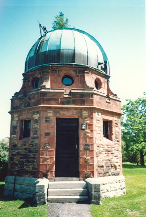
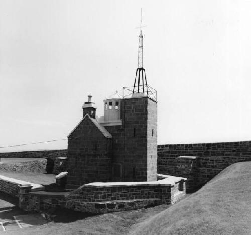
General view of the Photo Equatorial Building, 1992.
Photo: Department of Energy, Mines and Resources / Ministère de l'Énergie, des Mines et des Ressources, 1992.
- Built
- 1914
- Recognized
- 1992
- By
- Government of Canada
The register’s text, word for word
Description
The Photo Equatorial Building, also known as Building No. 9, is a small, symmetrical, one-storey, stone building that features a rusticated stone base, a crenellated cornice, round glazed window openings, and stone brackets supporting a retractable copper dome. Located at the north edge of the Central Experimental Farm National Historic Site of Canada on a campus-like site bounded by Carling Avenue and Observatory Drive, the Photo Equatorial Building forms a picturesque ensemble with the Dominion Observatory (1902-04) and the South Azimuth building (1912). The designation is confined to the footprint of the building.
Heritage value
The Photo Equatorial Building is a Classified Federal Heritage Building because of its historical associations, and its architectural and environmental values.
Historical value:
The Photo Equatorial Building is considered to be an extension of the Dominion Observatory due to the fact that it once played a supporting role in the Observatory’s scientific endeavours and sheltered astronomical equipment. As such, it is one of the best examples of the important historic theme of the advancement of pure and applied scientific research at the national level in Canada. Established to aid and improve the survey work of western Canada through the investigation and application of positional astronomy, the Observatory also served as a world-class centre for astronomical and geophysical research, and developed a national profile as the source of Dominion Observatory Official Time. The Photo Equatorial Building was built specifically to house the observatory’s stellar camera.
The Dominion Observatory is one of four major public buildings constructed in Ottawa during the expansionist years of the Wilfrid Laurier government as part of Laurier’s efforts to turn Ottawa into the –Washington of the north-, and heralded Ottawa’s transformation from a lumber town to a capital city. Scientists of national standing directly associated with the Observatory include its co-founders William Frederick King and Otto Julius Klotz, along with John Stanley Plaskett.
Architectural value:
The Photo Equatorial is an excellent example of an eclectic blend of Romanesque Revival and Edwardian Classicist styles. Built to shelter astronomical equipment, the Photo Equatorial Building is an elegant, octagonal building that resembles an English Baroque tempietto. Constructed of the highest quality materials and craftsmanship, the Photo Equatorial Building is characterized by a retractable, hemispherical copper dome, and a rich and vibrant palette of stone including a rusticated limestone base, rock-faced variegated Nepean sandstone walls and dressed red Sackville sandstone quoins and window and doors surrounds.
Environmental value:
The Photo Equatorial Building reinforces the picturesque character of the campus-like setting of the observatory within the Central Experimental Farm, by virtue of its distinctive design and materials. An essential part of the harmonious ensemble that includes the Dominion Observatory and South Azimuth buildings, the Photo Equatorial Building has long been familiar to the residents of Ottawa as part of the Dominion Observatory campus.
SourceJacqueline Hucker, Dominion Observatory, South Azimuth and Photo Equatorial buildings, Ottawa, Ontario. Federal Heritage Buildings Review Office Report 92-35, 92-41, 92-42; Dominion Observatory, South Azimuth and Photo Equatorial buildings, Ottawa, Ontario. Heritage Character Statement 92-35, 92-41, 92-42.
Character‑defining elements
The following character-defining elements of the Photo Equatorial Building should be respected.
Its eclectic blend of Romanesque Revival and Edwardian Classicist styles, excellent functional design, and extremely high quality materials and craftsmanship as manifested in:
- the form and symmetrical composition of the building;
- the distinctive and vibrant exterior treatment which is characterized by a rusticated limestone base, rock-faced variegated Nepean sandstone walls, and a contrasting smooth, red Sackville sandstone cornice and window and door surrounds;
- the building’s crenellated stone cornice;
- the roof level’s red Sackville sandstone base and brackets which support the retractable, hemispherical copper dome; and,
- the round glazed upper level windows.
The manner in which the building reinforces the picturesque character of the observatory’s campus-like setting within the Central Experimental Farm, as evidenced in:
-its distinctive design, materials and location which contribute to the harmonious relationship between the Dominion Observatory and South Azimuth Buildings as a picturesque ensemble.
End of the register’s text
Location
Ottawa, Ontario, Canada
45.39337° N, 75.71399° W
Get directions (opens in a new tab)Being on the register doesn’t make a place open to visitors. Many are private homes or businesses; please view them from the street.

Loading map…
Nearby
All 195 places in Ottawa Dominion Observatorywithin 100 m · 1902
 South Azimuth Buildingwithin 100 m · 1912
- Observatory Housewithin 100 m · 1909
 Geophysical Laboratory, Building 3within 100 m · 1954
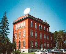 Seismology Survey Building100 m · Lieu historique national du Canada de la Ferme-Expérimentale-Centrale / Central Experimental Farm National Historic Site of Canada · 1913
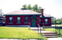 Machine Shop (#4)150 m · 1917
Similar places
Places whose register descriptions are closest to this one.
From the Canadian Register of Historic Places, as last updated on December 12, 2025. The register’s text is shown word for word.