Recognized Federal Heritage Building
Lower Brewers Defensible Lockmaster's House
Rideau Canal National Historic Site of Canada / Lieu historique national du Canada du Canal-Rideau, Ontario
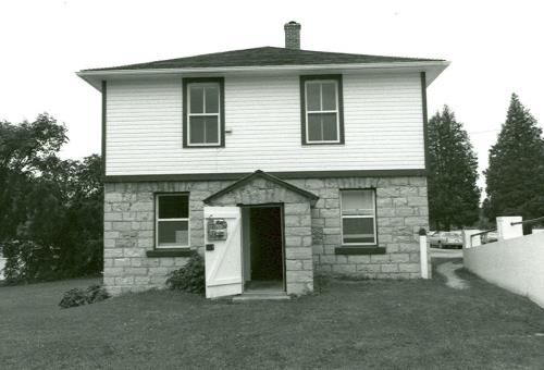
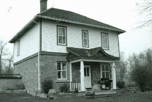
View of the main entrance of the Lower Brewers Defensible Lockmaster's House, showing the symmetrical elevations with regular placement of the windows and doors, 1989.
Photo: Department of Public Works / Ministère des Travaux publics, 1989.
- Built
- 1842
- Recognized
- 1990
- By
- Government of Canada
The register’s text, word for word
Description
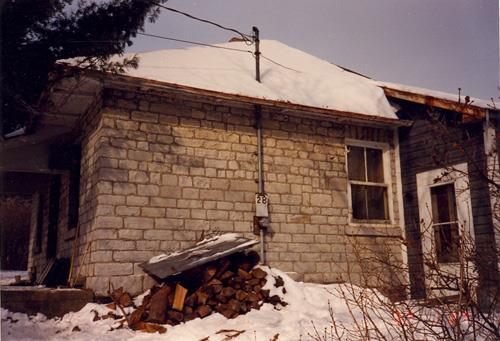
The Lower Brewers Defensible Lockmaster’s House overlooks the Rideau Canal and stands close to the lock at Lower Brewers Lockstation. It is a two-storey, cube-shaped building with a pyramidal roof and symmetrical façade. The ground floor walls are of limestone while the second-storey addition is clad in clapboard. The windows of the upper floor balance those of the lower and complete the symmetry. An enclosed porch protects the main entrance. The designation is confined to the footprint of the building.
Heritage value
The Lower Brewers Defensible Lockmaster’s House is a Recognized Federal Heritage Building because of its historical associations, and its architectural and environmental values.
Historical Value:
The Lower Brewers Defensible Lockmaster’s House is a good example of a building associated with the construction and operation of the Rideau Canal, and illustrates the theme of military defence for Upper and Lower Canada in the 19th century, and the evolution and transformation of the waterway as a federal public work. The establishment of a station at Lower Brewers stimulated the development of a milling community centred on a grist-mill, woollen mill and store.
Architectural Value:
The Lower Brewers Defensible Lockmaster’s House is valued for its good aesthetic design built as a defensible residence for the lockmaster. Later additions, such as the second storey and small wooden structure with porch to the rear, give the structure a more residential appearance. This resulted from a change in the function of the canal by the twentieth century from defence to recreation and commerce. The building exhibits very good functional design, which is evidenced in its dual function as a military structure and residence. Its materials and craftsmanship exemplify the high design standards of the Royal Engineers.
Environmental Value:
The Lower Brewers Defensible Lockmaster’s House reinforces the historic character of its park-like setting at Lower Brewers Lockstation and is a familiar landmark to local residents and to visitors.
SourceJames De Jonge, Fifteen buildings, Southern Area, Rideau Canal, Ontario, Federal Heritage Buildings Review Office, Building Reports 89-155, 89-156, 89-157, 89-158,89-159, and 89-160; Defensible Lockmaster’s House, Lower Brewers Lockstation, Rideau Canal, Ontario, Heritage Character Statement 89-155.
Character‑defining elements
The character-defining elements of the Lower Brewers Defensible Lockmaster’s House should be respected.
Its good aesthetic, very good functional design and very good quality materials and craftsmanship, for example:
- the two-storey massing with pyramidal roof, and chimney;
- the exterior walls, the thick ground floor wall constructed of evenly coursed limestone masonry with infilled loopholes, and the frame second floor clad in clapboard;
- the symmetrical elevations with regular placement of the windows and doors;
- the enclosed defensible porch and the wooden addition at the rear;
- the interior configuration.
The manner in which the Lower Brewers Defensible Lockmaster’s House reinforces the historic character of its park-like setting at Lower Brewers Lockstation and is a familiar local landmark, as evidenced by:
- its overall scale, design and materials, which harmonize with the lockstation surroundings;
- its visibility due to its prominent location adjacent to the canal, which makes it a local landmark.
End of the register’s text
Location
Rideau Canal National Historic Site of Canada / Lieu historique national du Canada du Canal-Rideau, Ontario, Canada
44.38900° N, 76.32500° W
Get directions (opens in a new tab)Being on the register doesn’t make a place open to visitors. Many are private homes or businesses; please view them from the street.

Loading map…
 Blockhouse14 km · Kingston · 1832
 Lockmaster's House14 km · Kingston Mills · 1904
 Shelter15 km · Saint Lawrence Islands National Park of Canada · 1950
 Aubrey Island Picnic Shelter15 km · Saint Lawrence Islands National Park of Canada · 1935
 Royal Military College of Canada Building 30a16 km · Kingston · 1846
 Shelter17 km · St. Lawrence Islands National Park of Canada / Parc national du Canada des Îles-du-Saint-Laurent · 1950
Similar places
Places whose register descriptions are closest to this one.
From the Canadian Register of Historic Places, as last updated on December 12, 2025. The register’s text is shown word for word.