L'Anse aux Meadows National Historic Site of Canada
Also known as: L'Anse aux Meadows National Historic Site of Canada, L'Anse aux Meadows, L'Anse aux Meadows
Description
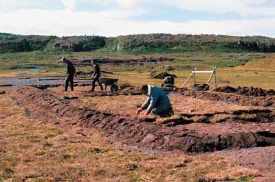
L'Anse aux Meadows National Historic Site of Canada comprises the archaeological remains of an early Viking settlement situated on the eastern shore of Epaves Bay, 1 km south of the village of L'Anse aux Meadows at the tip of the Great Northern Peninsula in Newfoundland. Parks Canada has erected a partial reconstruction of the habitation for purposes of public presentation.
Heritage Value
L'Anse aux Meadows was designated a national historic site of Canada because it is:
- the first known site established by Vikings in North America, and
- the earliest evidence of Europeans in Canada.
The heritage value of the site lies in the archaeological evidence of early Viking presence in Canada. The location, surroundings and disposition of the site together with the nature of the remains it contains provide both an essential record and legible description of Viking life on the site. In ca. 1000 AD, l'Anse aux Meadows was established as exploration base Leifsbuoir/ Straumfjord, popularly known as Leif Ericsson's short-lived Vinland camp. It has been conserved and interpreted as a national historic site of Canada.
Sources: Historic Sites and Monuments Board of Canada, 1968 Minutes; Commemorative Integrity Statement, 1998.
Character-Defining Elements
Key elements contributing to the heritage value include:
- location on the very northern edge of the Great Northern Peninsula on the Strait of Belle Isle;
- the siting on a narrow dry terrace back from the beach and bounded by sedge peat bogs;
- the layout of the site as three grouped complexes of eight separate building remains, associated structures and middens;
- the archaeological remains of sod walls and timber frames;
- archaeological evidence of specific functions including dwellings, an iron-making bloomery, refuse pits, and boat repair sites;
- presence of fresh water brook, bog iron ore;
- the spatial relationships between and among remains on the site;
- viewscapes to nearby surroundings (bogs, small brook, and harbour basin), neighbouring coves;
- viewscapes to landmarks marking the route from the site to the sea (Great Sacred Island, Flat Island, distinctive capes and knolls),
- viewplanes over the Strait of Belle Isle, the offshore islands, the Labrador coast.
Gallery
3 imagesLocation
Loading map...
Similar Places
Heritage sites with similar characteristics