Ressource historique provinciale
Magrath Canal
Magrath, Alberta
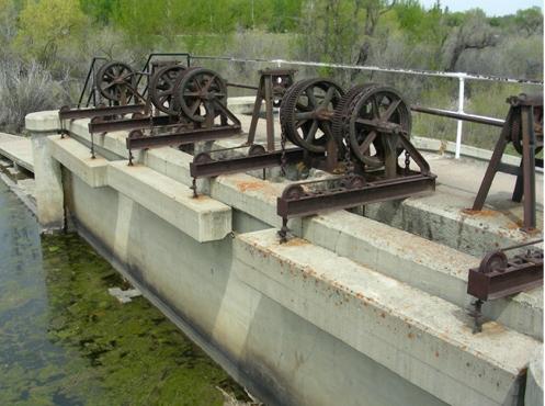
Photo: Alberta Culture and Community Spirit, Historic Resources Management, 2006
- Construction
- 1898–1900
- Reconnaissance
- 1987
- Par
- Province de l'Alberta
Le texte du répertoire, mot pour mot
Description
Magrath Canal is an irrigation canal situated on 8.09 hectares of land within the J. Arthur Spencer Historical Park in the Town of Magrath. The site features the remains of original wooden piers, the ruins of the diversion weir, and associated gates and dams.
Valeur patrimoniale
The heritage value of Magrath Canal lies in its association with the establishment of an extensive irrigation system in southern Alberta and its connection to the opening of a vast region in the province's south to settlement, particularly by Mormons.
Prior to the 1890s, much of southern Alberta had been perceived as unsuitable for agricultural settlement. Enclosed within "Palliser's Triangle" - an arid expanse in the southern Canadian Prairies - the region had been largely avoided by settlers convinced of its dubious farming possibilities. This dreary vision was of particular concern to Elliott Galt, whose companies had amassed vast land subsidies in the area in return for constructing railway lines. In the 1890s, Galt and his associate A. C. Magrath of the Alberta Irrigation Company (later the Canadian North-West Irrigation Company) spearheaded the St. Mary River Project to address the problem of aridity in southern Alberta. Galt succeeded in securing the support of the federal government, the Mormon community, and British investors for the project. The government agreed to offer a rebate on the surveying fees associated with the endeavour in order to encourage settlement in an otherwise unattractive region. The Mormons offered their labour and their considerable expertise on irrigation - cultivated through years of "making the desert bloom" in Utah - in exchange for land and cash payments. And the financiers agreed to provide capital in the hopes of substantial returns. Begun in 1898, the St. Mary River Project was completed in 1900. As a result of this happy confluence of interests, vast tracts of southern Alberta were made viable for agriculture and settlement. The St. Mary River Project, of which the Magrath Canal was a part, was the first major irrigation project undertaken in Alberta and was essential in transforming the image of southern Alberta from a dry, desolate land unsuitable for agriculture to a region made fruitful by irrigation. The establishment of the communities of Magrath, Raymond, and Stirling was directly linked to the project.
SourceAlberta Culture and Community Spirit, Historic Resources Management Branch (File: Des. 993)
Éléments caractéristiques
The character-defining elements of Magrath Canal include such features as:
- mass, form, and scale;
- remaining wooden piers;
- concrete dam;
- composite concrete and iron gates systems, including chains, cables, and gears;
- chains and cables;
- remains of diversion weir;
- remains of staircases, ladders, and access points.
Fin du texte du répertoire
Emplacement
49.40388° N, 112.87022° W
Itinéraire (s’ouvre dans un nouvel onglet)L’inscription au répertoire ne rend pas un lieu accessible au public. Beaucoup sont des résidences ou des commerces privés; admirez-les depuis la rue.

Chargement de la carte…
À proximité

Lieux semblables
Les lieux dont la description du répertoire se rapproche le plus de celle-ci.
Tiré du Répertoire canadien des lieux patrimoniaux, dans sa dernière mise à jour du 12 décembre 2025. Le texte du répertoire est reproduit mot pour mot.