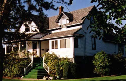
Photo: Denise Cook Design
- Construction
- 1912
- Reconnaissance
- 1987
- Par
- Administrations locales (C.-B.)
Le texte du répertoire, mot pour mot
Description
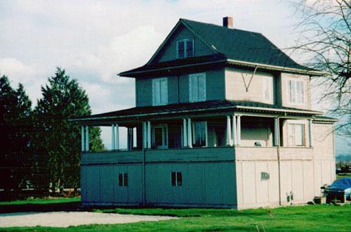
The Eldstrom House is a two storey, front gable house with a side gable extension situated at the front of a long narrow lot with lawn and mature trees, and fronting a rural road. The historic place consists of the building footprint.
Valeur patrimoniale
The Eldstrom House, built by Lust Eldstrom in the early twentieth century, is recognized primarily for its historical connection to the fishing and farming history of the South Arm area of Richmond. This area was one of the earliest farming districts on Lulu Island, and retains much of its agricultural character today. In particular, the house represents the experience of settlers from Finland who arrived in Richmond in the late nineteenth century, settling along the sloughs and participating in the Fraser River fishery. Many eventually purchased land in the area on which they cultivated vegetables and livestock in addition to fishing.
Set at the front of a narrow lot, the design of the house is representative of Richmond's very early South Arm rambling utilitarian farmhouses, with its gabled roof and front verandah. The landscape with its large narrow lot and mature trees, and the orientation of the house to Finn Road and Woodward's Slough reflect the original settlement patterns in this area when transportation was primarily by boat.
SourceCity of Richmond Clerk's Department File #4200-02
Éléments caractéristiques
Character defining elements of the Eldstrom House include:
- The location of the house in the South Arm area of Richmond and the spatial orientation of the house to the front of the narrow lot facing the slough and the road
- The overall design of the house, including its L-shaped plan, rectangular massing, front gable roof with side gable extension, central chimney and front open verandah with shed roof and square columns
- Details of the construction including front and side gable dormers with returned eaves, fish scale shingles in the gable ends, and the front door
Fin du texte du répertoire
Emplacement
49.12016° N, 123.11708° W
Itinéraire (s’ouvre dans un nouvel onglet)L’inscription au répertoire ne rend pas un lieu accessible au public. Beaucoup sont des résidences ou des commerces privés; admirez-les depuis la rue.

Chargement de la carte…
À proximité
Les 35 lieux de Richmond
Lieux semblables
Les lieux dont la description du répertoire se rapproche le plus de celle-ci.
Tiré du Répertoire canadien des lieux patrimoniaux, dans sa dernière mise à jour du 12 décembre 2025. Le texte du répertoire est reproduit mot pour mot.