Dewdney Trail
Description
This section of the Dewdney Trail is on the lands of the Okanagan, Sinixt, Secwepemc, Splats'in, Shuswap and Ktunaxa Nations. The original Dewdney Trail was a 700 km long, all-Canadian route along the southern border of the newly established colony of British Columbia. The Dewdney Trail (Rossland Section) is the 2,377-metre portion of the trail located southeast of city centre, located in the proximity of Redstone Resort and within Rossland City Limits.
Valeur patrimoniale
The first engineered land transportation corridor in the Rossland area, the Dewdney Trail (Rossland Section), "the Trail" is significant for its economic, cultural, social and particularly for its historic role in providing access to prospectors who made the first mineral claims in 1890. Particularly, prospectors Morris and Bourgeois who staked The Lily May claim located beside the Trail and therefore established the beginning of the Rossland mining era and subsequent creation of the Rossland town site.
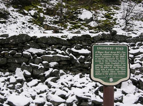
The Trail is a rare surviving example of the physical infrastructure specified by the Royal Engineers for mule train traffic, particularly its specifications for maximum grade no steeper than 1 in 12 and a one-and-a-half foot wide bed with a four foot clear width at shoulder height for the passage of laden mules.
The Trail is valued for its contribution to the physical and economic development of the City of Rossland and neighbouring settlements that would become key for processing Rossland’s ore and therefore contribute to the economic stability of the City and region. The Trail also helped secure the control of land and trade in the region immediately north of the nearby American frontier line that extended across the natural north-south mountain ranges and trade routes and dividing the Colony from American territory. The Trail was the earliest overland access connecting Rossland to the Pacific coast and eastern BC. It was used mainly by early prospectors, miners and traders from 1865 until rail lines and motor roads supplanted it in the 1890s.
The Trail is culturally significant, as many historic trails in British Columbia often have a connection to earlier First Nation trails along the same routes. The existing network of First Nation trails was a significant foundation for making many newcomer activities possible, including exploration, travel, transportation of goods, communications and economic development. The Trail is valued for the stories of its builders that include First Nations and Chinese crews, as well as the Royal Engineers.
The Trail is valued today by mountain bikers and hikers and used as a beautiful recreation trail maintained by the Kootenay Columbia Trail Society.
Éléments caractéristiques
The character-defining elements of the historic place include its:
- Original route of the Trail 2,377 metres located within the boundaries of Rossland City Limits beginning southeast Rossland at the intersection of the Rubberhead Trail, continuing northeastward to Redstone Golf Club, Hole 15, past the historic Valley House and continuing through Holes 2-8.
- Visible and remaining sections of the Trail are accessible from Redstone Resort, Hole 15 and the Rubberhead Trail.
- Geometry of the roadbed: original 4-foot width and grade no steeper than 1 in 12.
- Associated land works, including dry rock retaining walls and excavations.
Location
Loading map...
Lieux similaires
Sites patrimoniaux avec des caractéristiques semblables