Provincial Park (Establishment)
Fintry Haybarn-Granary
near Kelowna, British Columbia
Also known as Fintry Hay Barn, Fintry Haybarn, Fintry Granary
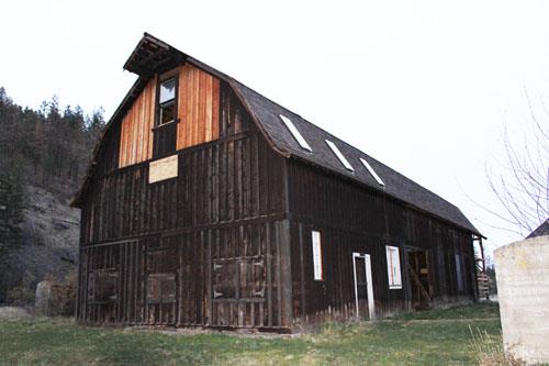
Fintry Haybarn-Granary
Photo: Ministry of Environment, BC Parks, 2010
- Recognized
- 1995
- By
- Province of British Columbia
The register’s text, word for word
Description
The Fintry Haybarn-Granary is a gambrel-roofed structure situated immediately to the west of the Octagonal Dairy Barn in Fintry Provincial Park near Kelowna, British Columbia. It is part of a complex of related buildings and structures known locally as the Fintry Estate.
Heritage value
Built in the mid-1920s, the Fintry Haybarn-Granary is significant because it conveys the scale and vision of the agricultural operations developed by James C. Dun-Waters at the Fintry Estate between 1909 and 1939.
The Fintry Haybarn-Granary reveals the scale of the cow and horse herds, and the existence of hay and grain-growing lands that were part of the estate's agricultural operation. The building is also important because it houses a mill for processing grain supplied by grain harvested from the estate's delta lands.
This building, fitted with a Pelton water turbine, also represents the isolation of the estate far from the developing electrical grid in the Okanagan, its singular hydro asset in the form of the precipitous run of Shorts Creek to its delta, and the ambition of Dun-Waters himself.
SourceMinistry of Environment, BC Parks
Character‑defining elements
Key character-defining elements of the Fintry Haybarn-Granary include:
Site:
-location as part of a cluster of barn buildings
-orthogonal relationships within the cluster
-association with nearby hayfields
Building:
-simple gambrel roof form with ridge extension for hoist track
-two distinct parts of the building sharing a single gable roof: open hay storage end and closed granary end
-remaining original wood windows and doors and associated hardware
-remains of mill, Pelton wheel, and hydro infrastructure
End of the register’s text
Location
near Kelowna, British Columbia, Canada
50.13713° N, 119.50391° W
Get directions (opens in a new tab)Being on the register doesn’t make a place open to visitors. Many are private homes or businesses; please view them from the street.

Loading map…
Similar places
Places whose register descriptions are closest to this one.
From the Canadian Register of Historic Places, as last updated on December 12, 2025. The register’s text is shown word for word.