Community Heritage Register
Dallas Square Cenotaph
Nanaimo, British Columbia
Also known as War Memorial
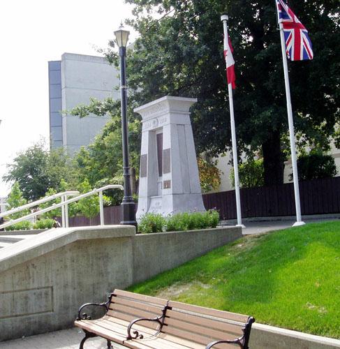
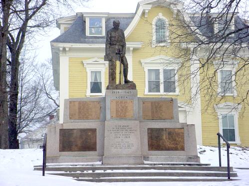
View of the Dallas Square Cenotaph and adjoining park area
Photo: City of Nanaimo, Christine Meuztner, 2006
- Built
- 1921
- Recognized
- 2002
- By
- Local government
The register’s text, word for word
Description
The Dallas Square Cenotaph is a 14-foot high granite monument with plaques commemorating those lost in World Wars I and II and the Korean War. The cenotaph is located in a small public park on a main downtown thoroughfare, overlooking the harbour.
Heritage value
The Dallas Square Cenotaph, built in 1921 to commemorate local men who died during World War I, represents deeply felt community sensibilities about memory, war and loss. The cenotaph is still used as a memorial site and bears witness to annual Remembrance Day ceremonies, giving the community an important opportunity to gather and remember together.
The Dallas Square Cenotaph is the focal point of a small municipal park bordered by trees and St. Paul's Anglican Church yard on three sides. Facing a busy downtown street and the harbour, the Dallas Square Cenotaph and adjacent grounds are highly visible and provide a calm and restful green space in the downtown core.
The Dallas Square Cenotaph is a very good example of a simple, graceful monument. Minimally ornamented, the Cenotaph's design, created and executed by local monument works owner C.E.J. Millins, was based on an ancient Egyptian model.
SourceCity of Nanaimo, Development Services Department
Character‑defining elements
The character-defining elements of the Dallas Square Cenotaph include its:
- location in the center of a small municipal park, facing a main street and the harbour
- clean, graceful lines, minimal ornamentation and granite construction
- bronze plaques listing the names of those who died in World Wars I and II and the Korean War
End of the register’s text
Location
85 Church Street, Nanaimo, British Columbia, V9R, Canada
49.16801° N, 123.93693° W
Get directions (opens in a new tab)Being on the register doesn’t make a place open to visitors. Many are private homes or businesses; please view them from the street.

Loading map…

Similar places
Places whose register descriptions are closest to this one.
From the Canadian Register of Historic Places, as last updated on December 12, 2025. The register’s text is shown word for word.