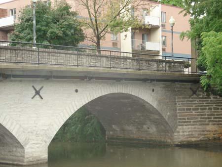
Of note is the use of locally quarried limestone.
Photo: Martina Braustein, 2007.
- Built
- 1884
- Recognized
- 1979
- By
- Local government
The register’s text, word for word
Description
The Church Street Bridge spans Trout Creek, between Station Street and Queen Street East, in the Town of St. Marys. The two-arch stone bridge was constructed in 1884.
The property was designated, by the Town of St. Marys, in 1979, for its architectural value or interest, under Part IV of the Ontario Heritage Act, By-law 16 of 1979. The Church Street Bridge has also been listed on the Ontario Heritage Bridge list, a list of provincially significant bridges maintained by the Ministry of Culture.
Heritage value
The Church Street Bridge blends harmoniously with the surrounding cultural heritage landscape and affords pleasing views both up and down Trout Creek.
The Church Street Bridge is one of two surviving stone bridges in the Town of St. Marys. It was constructed in 1884 to replace an earlier wooden bridge at the same location. It was built using designs by local architect William Williams. William Williams is also notable for having designed several residences, at that time and for serving as Town Clerk. James Clyde and James Elliott, local stonemasons, constructed the bridge.
The Church Street Bridge is a stone arch bridge constructed of local limestone. Stone bridges were rare in Ontario, during the later half of the 19th century, because of the time, money and skills required for their construction. The bridge has two arches that span 80 feet and a width that accommodates two lanes of traffic.
SourceTown of St. Marys By-Law 16 of 1979.
Character‑defining elements
Character defining elements that contribute to the heritage value of the Church Street Bridge include its:
- construction of local limestone
- stone arch construction
- size and original dimensions, including its 80 foot span and two lane road width
- location spanning Trout Creek
End of the register’s text
Location
0, Church Street North, St. Marys, Town of, Ontario, N4X, Canada
43.26142° N, 81.14115° W
Get directions (opens in a new tab)Being on the register doesn’t make a place open to visitors. Many are private homes or businesses; please view them from the street.

Loading map…
Nearby
All 27 places in Town of
Similar places
Places whose register descriptions are closest to this one.
From the Canadian Register of Historic Places, as last updated on December 12, 2025. The register’s text is shown word for word.