Municipal Heritage Property
Chimney Coulee Site
Arlington RM 79, Saskatchewan
Also known as Hunter's Settlement, Chapel Coulee, Archaeological Site DjOe-6
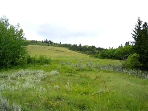
Looking west at site area in clearing to the middle and rear of photo, 2004.
Photo: Government of Saskatchewan, Marvin Thomas, 2004.
- Recognized
- 1992
- By
- Local government
The register’s text, word for word
Description
The Chimney Coulee Site is a Municipal Heritage Property encompassing 12.5 hectares of land in a ravine on the east slope of the Cypress Hills. The site is located approximately 6 km north of the Town of Eastend, adjacent to the Chimney Coulee Provincial Historic Site. The property features archaeological remains of a Métis wintering village and a North-West Mounted Police post.
Heritage value
The heritage value of the Chimney Coulee Site lies in its association with Métis settlement on the Canadian prairies during the mid- to late-nineteenth century. By at least mid-century, Métis hunters were pushing as far west as the Cypress Hills in pursuit of dwindling bison herds. Some may already have been wintering in Chimney Coulee by that time. The earliest undisputed evidence for a Métis presence at the site comes from Isaac Cowie, who operated a Hudson’s Bay Company post in the coulee over the winter of 1871-1872. During the 1870s, as many as sixty Métis families may have occupied the coulee (then known as “Hunter’s Settlement”) on a seasonal basis. With the disappearance of the bison from the area, it is believed that the Métis had largely abandoned Chimney Coulee by about 1880.
Further heritage value resides in the property’s connection with the North-West Mounted Police, who established an outpost in the coulee in 1876. “East End Post” operated intermittently until about 1887, primarily as a way station for police patrols between Fort Walsh and Wood Mountain. For a time, the post had a prominent role monitoring Sitting Bull (Ta-tanka Yotanka) and his people, who had sought refuge in Canada following the Battle of Greasy Grass/Little Big Horn.
The property is also valued for its association with the remains of Cowie’s fur trade post on the adjacent historic site, and for its natural setting in a partially wooded ravine. Little changed since the nineteenth century, the property represents the local environment much as it would have been experienced by its various past inhabitants.
Source:
Rural Municipality of Arlington No. 79 Bylaw No. 229.
Character‑defining elements
The heritage value of the Chimney Coulee site resides in the following character-defining elements:
-the site in its defined boundaries in the natural setting of the coulee;
-those elements that reflect nineteenth-century use of the site, such as man-made pits and depressions, trail remnants, buried building foundations or other construction features, and artifact deposits, especially remains in their original location and context.
End of the register’s text
Location
Arlington RM 79, Saskatchewan, S0N, Canada
49.57316° N, 108.80941° W
Get directions (opens in a new tab)Being on the register doesn’t make a place open to visitors. Many are private homes or businesses; please view them from the street.

Loading map…
Nearby
Similar places
Places whose register descriptions are closest to this one.
 Herschel Petroglyph/Tipi Ring SiteMountain View RM 318, Saskatchewan
 Crippled Creek Crossing SiteGravelbourg RM 104, Saskatchewan
 Moore's RavineGrandview RM 349, Saskatchewan
 Petite VilleRosthern RM 403, Saskatchewan
 Saint Andrews Anglican ChurchPorcupine RM 395, Saskatchewan
 Smith Barn SiteHappyland RM 231, Saskatchewan
From the Canadian Register of Historic Places, as last updated on December 12, 2025. The register’s text is shown word for word.