Designated Historic Place
Atwell House
Clyde River, Prince Edward Island
Also known as Lane Property, Dog River Farm
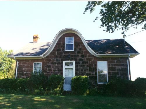
Showing sandstone construction and "nun's hood" dormer
Photo: Province of PEI
- Built
- 1842
- Recognized
- 2001
- By
- Province of Prince Edward Island
The register’s text, word for word
Description
The Atwell House is located in the rolling pastoral landscape of Clyde River, PEI, adjacent to the Trans Canada Highway. It is a rare 19th Century Island sandstone house set on the hillside and surrounded by treed lawns. The designation includes the footprint of the building.
Heritage value
The Atwell House is notable for its use of Island sandstone in its construction. It is one of only 8 remaining sandstone homes built in 19th Century PEI. The property that Atwell House now sits on was originally glebe land. In 1837, this land was given to Ambrose Lane by his father-in-law, Lt. Governor C.D. Smith. Lane had a varied and influential career as an army and militia officer, politician, and judge. Lane sold the land to Thomas Kickham in 1840. It is believed the house was built in 1842 using proceeds from the sale of the adjacent farm. Kickham called the property the Dog River Farm for the river running below it, later to be renamed the Clyde.
Local tradition maintains that the stone for the house was taken from the farm property, and construction was undertaken by local stone masons, Thomas and John Heartz. It is also believed that the finish work carpentry was done with timber sent from the Island to England and then returned for installation, arriving by ship at a dock formerly on the property.
In 1843, Ambrose Lane re-acquired the property and used it as a hunting lodge. After his death in 1853, it saw a number of owners and became known variously as Sherwood Farm and later Atwell House, after the family who owned it in the 1970s.
SourcePEI Heritage Advisory Committee Files
Character‑defining elements
The following elements embody the heritage value of the Atwell House:
- the Island sandstone construction
- the eyebrow or "nun's hood" dormer on the front elevation
- the 21 inch cavity walls
- the "central fireplace plan" interior configuration of rooms
- the size and placement of the doors and windows
- the end gable returns
End of the register’s text
Location
14718 Trans Canada Highway, Route 1, Clyde River, Prince Edward Island, C0A, Canada
46.22561° N, 63.25247° W
Get directions (opens in a new tab)Being on the register doesn’t make a place open to visitors. Many are private homes or businesses; please view them from the street.

Loading map…
Similar places
Places whose register descriptions are closest to this one.
From the Canadian Register of Historic Places, as last updated on December 12, 2025. The register’s text is shown word for word.