National Historic Site of Canada
Wreck of Breadalbane National Historic Site of Canada
Beechey Island, Nunavut
Also known as Wreck of Breadalbane, Épave du Breadalbane, Breadalbane
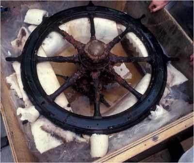
General view of the helm from the Wreck of Breadalbane.
Photo: Parks Canada Agency | Agence Parcs Canada
- Built
- 1843
- Recognized
- 1983
- By
- Government of Canada
The register’s text, word for word
Description
The Wreck of Breadalbane National Historic Site of Canada is located off Beechey Island, Nunavut well above the Arctic Circle and is the most northerly known shipwreck. The site is comprised of the wreckage of Breadalbane, a 19th-century, 500-ton sailing ship, including the hull, fragments of the vessel and the debris field caused by the sinking of the ship. The shipwreck is also a component of Beechey Island Sites National Historic Site of Canada. The designation refers to the shipwreck itself and the debris field that surrounds it.
Heritage value
The Wreck of Breadalbane was designated a national historic site of Canada in 1983 because:
- the ship was involved in the search for Captain John Franklin’s lost expedition.
Breadalbane was built in 1843 in a shipyard on the Clyde River in Scotland. It spent the first few years of its existence as a merchant vessel, travelling as far as Calcutta. After the disappearance of Sir John Franklin’s expedition, which was searching for the Northwest Passage, Breadalbane was pressed into service by the British Admiralty to supply the vessels which were exploring the Arctic waters in search of Franklin and his crew. It left the Thames River in 1853, accompanying HMS Phoenix, and arrived at the rallying point for the search parties at Beechey Island later that year. However, the Arctic weather did not co-operate and Breadalbane soon found itself surrounded by slow-moving yet implacable pack ice. The ship was quickly emptied of as many supplies and personal effects as possible. On the night of August 20-21, the ice finally broke through the hull, sinking Breadalbane to the floor of Barrow Strait.
SourceHistoric Sites and Monuments Board of Canada, Minutes, July 2007.
Character‑defining elements
Key elements contributing to the heritage value of this site include:
- its location well above the Arctic Circle within Beechey Island Sites National Historic Site of Canada in Nunavut;
- the underwater archaeological remains of the ship, including the hull, fragments of the vessel and the surrounding debris field;
- the integrity of any surviving or as yet unidentified archaeological remains associated with the wreck, which may be found within the site in their original placement and extent, including all remains of a navigational or personal nature.
End of the register’s text
Location
Beechey Island, Nunavut, Canada
74.68417° N, 91.83556° W
Get directions (opens in a new tab)Being on the register doesn’t make a place open to visitors. Many are private homes or businesses; please view them from the street.

Loading map…
Nearby
Similar places
Places whose register descriptions are closest to this one.
 Wrecks of HMS Erebus and HMS Terror National Historic Site of CanadaGjoa Haven, Nunavut
 Wreck of the Elizabeth and Mary National Historic Site of CanadaBaie-Trinité, Quebec
 Beechey IslandResolute, Nunavut
 Bay Bulls Harbour Provincial Historic SiteBay Bulls, Newfoundland And Labrador
- City of Ainsworth ShipwreckGray Creek, British Columbia
- Lord Western ShipwreckHot Springs Cove, British Columbia
From the Canadian Register of Historic Places, as last updated on December 12, 2025. The register’s text is shown word for word.