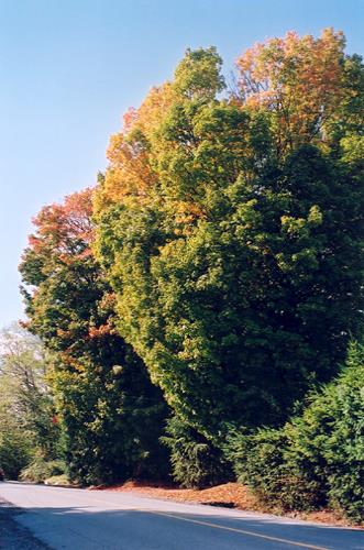
View of Sugar Maple Trees, 2003
Photo: City of Maple Ridge, 2003
- Built
- 1914
- Recognized
- 1999
- By
- Local government
The register’s text, word for word
Description
These two landmark Sugar Maple trees stand approximately 25 metres tall on the edge of an historic rural road in Whonnock, between a public transportation route and a private lot located at 26721 100 Avenue, Maple Ridge.
Heritage value
The heritage value of these mature Sugar Maples (Acer saccharum) is their association with early settlement of pioneering families coming from Eastern Canada in the late nineteenth and early twentieth centuries. William Charles Drewry (1876-1948) and his wife, Mary Jane Drewry (1880-1964), arrived in Whonnock from Perth, Ontario in 1914 and established a poultry farm. They brought these two trees with them as saplings, to act as a reminder of their former home.
Possessing a particular reverence within the community of Maple Ridge as a symbol of the City, the Sugar Maples are reminders of early settlers who came from other parts of Canada and abroad and helped to form what is now Maple Ridge. The maples also indicate the domestication of the once wild and undeveloped property in Whonnock that would have occurred as settlers occupied local lands.
The historic community of Whonnock is characterized both by its rural and treed nature, heightened by these Sugar Maples.
SourcePlanning Department, City of Maple Ridge
Character‑defining elements
Key elements that define the heritage character of these two mature Sugar Maples include their:
- species (Acer saccharum)
- orientation to 100 Avenue, which is an important historic road, marking the transition from a public transportation route to private property
- presence of the pairing two mature specimens as part of the streetscape
- proportion and massing of the tree canopies
- deciduous nature of the trees, changing with the seasons: creating shade in the summer and vivid fall foliage in the autumn
End of the register’s text
Location
26721 100 Avenue, Maple Ridge, British Columbia, Canada
49.18491° N, 122.48196° W
Get directions (opens in a new tab)Being on the register doesn’t make a place open to visitors. Many are private homes or businesses; please view them from the street.

Loading map…
Similar places
Places whose register descriptions are closest to this one.
 Blair Sugar Maple TreeTownship of Langley, British Columbia
 Maple Ridge CemeteryMaple Ridge, British Columbia
 Wright Memorial Maple TreeTownship of Langley, British Columbia
 Wilson Memorial Maple TreeTownship of Langley, British Columbia
- Queensborough Northern Red OakNew Westminster, British Columbia
 Avenue of TreesSurrey, British Columbia
From the Canadian Register of Historic Places, as last updated on December 12, 2025. The register’s text is shown word for word.