Territorial Historic Site
Nagwichoo tshik (Mouth of the Peel)
Mouth of the Peel River, Northwest Territories
Also known as Mouth of the Peel, Nagwichoo tshik
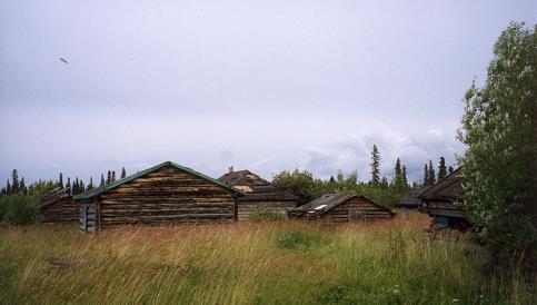
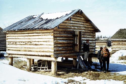
Cabins at Mouth of the Peel Village
Photo: I. Kritch, GSCI 1996
- Recognized
- 2010
- By
- Government of the Northwest Territories
The register’s text, word for word
Description
The Gwich’in name, Nagwichoo tshik, means ‘at the mouth of the big country river’, referring to the Mackenzie River. The site is also called the Mouth of the Peel Village. The abandoned village is located in the Mackenzie Delta at the confluence of the Peel and Mackenzie Rivers. During the early to mid 20th century, it was a thriving community. Situated about 50 kilometres downstream from Fort McPherson, it sits on a rise overlooking the Peel River. Between the village and the river to the north are willow flats; a small pond borders the village to the south. There are many structures still standing consisting of log cabins, raised and ground level warehouses, smoke houses, and outhouses. The area is approximately 125 hectares. The site overlaps partially with Gwich’in Heritage Conservation Zone H09.
Heritage value
Prior to the contact period, this area was not within the traditional range of the Teetl’it Gwich'in. Both the Teetl’it Gwich'in and the Siglit (Inuvialuit) considered the lower 80 kilometres of the Peel drainage and the head of the Mackenzie Delta a no-man’s-land, because of the potential for conflict when they met. After the HBC opened the Fort McPherson post in 1840, more frequent violent interactions occurred. These battles are now part of the Teetå’it Gwich'in oral history.
Mouth of the Peel Village is associated with events that have shaped the history of the Northwest Territories. These are related to the fur trade and most particularly, the growth and decline of muskrat trapping during the early twentieth century. During this period, Nagwichoo tshik developed into an important village, used as a base for muskrat trapping in the spring and as a fishing camp during the summer. People stayed at Mouth of the Peel year round, fishing, trapping and hunting in the area. Supply boats would stop there on their way north and several stores were established. With the decline of the muskrat populations in the 1970s, the number of village inhabitants also decreased. Today the village sees sporadic use as a venue for educational programs and recreation. Elder Neil Colin, affectionately known as “The Mouth of the Peel”, still spends considerable time there along with his family. The site is representative of the Teetl’it Gwich'in way of life and tradition.
This is the only historic village still standing in the Gwich’in Settlement Region. The heritage value of the site lies in both the architecture and continued use of the buildings. The buildings at Mouth of the Peel are definitely an important component of the site and greatly contribute to its heritage value. They are tangible remains of the past and stand in the landscape as witnesses of the history that has unfolded there.
Character‑defining elements
Character-defining elements include:
- The sole historic village still standing in the Gwich’in Settlement Area.
- The imbedded history of the muskrat trade and subsequent decline.
- Provides a tangible link to Teetl’it Gwich’in oral tradition, place names and traditional practices that define the site.
- The vernacular architecture used in the buildings: chinked round-logs, square notch corner construction, sod roofs on some buildings.
- The original materials and construction style, dating to its occupation by the builders.
- The remains of sawmill.
- Numerous graves are associated with the village.
- The village’s location at the junction of the Peel River and the Mackenzie River – two major travel corridors.
- The site of battles between the Gwich’in and the Siglit.
- Close association with Neil Colin, a prominent and popular Gwich’in elder.
- The natural landscape around the site contributes to its heritage value.
- The viewscape of the Peel River from the Village.
End of the register’s text
Location
Mouth of the Peel River, Northwest Territories, Canada
67.68694° N, 134.56833° W
Get directions (opens in a new tab)Being on the register doesn’t make a place open to visitors. Many are private homes or businesses; please view them from the street.

Loading map…
Similar places
Places whose register descriptions are closest to this one.
 Nagwichoonjik (Mackenzie River) National Historic Site of CanadaTsiigehtchic, Northwest Territories
 Nataiinlaii (Eight Miles) Territorial Historic SiteNataiinlaii, Northwest Territories
 Khaii Luk TshikKhaii Luk Tshik, Northwest Territories
 Knut Lang's PlaceKnut Lang's Place, Northwest Territories
 Teetshik Goghaa (Old Arctic Red) Territorial Historic SiteOld Arctic Red, Northwest Territories
 Pokiak Terriorial Historic SitePokiak, Northwest Territories
From the Canadian Register of Historic Places, as last updated on December 12, 2025. The register’s text is shown word for word.