Recognized Federal Heritage Building
Kinkade Farmstead
Qualicum Beach, British Columbia
Also known as Kinkade Farmstead, Farmhouse, Kinkade Farmstead, Maison, Kinkade House
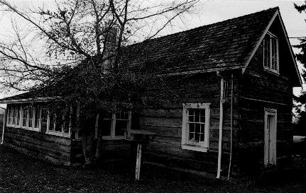
South and east façades of Kinkade Farmstead, showing the squared-log hand hewn walls with dovetailed corner-notches, the gabled end walls of cedar and the cedar shingle pitched roof, 1999.
Photo: Parks Canada Agency / Agence Parcs Canada, Mills, 1999.
- Built
- 1882–1884
- Recognized
- 1999
- By
- Government of Canada
The register’s text, word for word
Description
Kinkade Farmstead is located on low-lying land bordering the estuary of the little Qualicum River. It is a small rectangular, one-and-a-half -storey farmstead structure, with hand hewn squared-log walls and a cedar shingle pitched roof. The structure features a two-storey addition and a sun porch. The designation is confined to the footprint of the building.
Heritage value
Kinkade Farmstead is a Recognized Federal Heritage Building because of its historical associations, and its architectural and environmental values.
Historical Value:
Kinkade Farmstead is a useful example of a building associated with the broad theme of European settlement in coastal British Columbia. Built by Thomas Kinkade, a pioneer settler, it is also the oldest of the few surviving pioneer settlement houses along the east coast of Vancouver Island. The farmstead was donated to the federal government in 1974 as a wildfowl sanctuary.
Architectural Value:
Kinkade Farmstead is significant architecturally as a good, early surviving example of late 19th-century pioneer vernacular design. A squared log farmstead house with simple detailing, it is distinguished by its good functional design and by its construction using solid materials.
Environmental Value:
Kinkade Farmstead preserves many of the original spatial and visual relationships with outbuildings and other remaining elements of the former farmstead setting. The vernacular design and squared-log construction of the house contribute significantly to the setting as a whole. It reinforces, and is compatible with, the present character of the Kinkade Farmstead. Known today as the Marshall-Stevenson Unit of the Qualicum National Wildlife Area, much of the farmstead layout and landscape character remain intact.
SourceEdward Mills, Kinkade Farmstead (farmhouse, barn and two sheds), Marshall-Stevenson National Wildlife Area, 3567 Island Highway West, Qualicum Beach, British Columbia. Federal Heritage Buildings Review Office Report 98-073; Kinkade Farmstead / Kinkade House, 3567 Highway West, Qualicum Beach, British Columbia. Heritage Character Statement 98-073.
Character‑defining elements
The following character-defining elements of the Kinkade Farmstead should be respected.
Its functional design and good quality materials and craftsmanship such as:
- the one-and-a-half-storey rectangular massing, the two-storey section on the north elevation, and the sun porch on the west elevation of the house;
- the squared-log hand hewn walls with dovetailed corner-notches;
- the gabled end walls of cedar and a cedar shingle pitched roof;
- the fireplace and chimney, and interior stair;
- the surviving original fenestration and door openings.
The manner in which the Kinkade Farmstead reinforces the rural character of the low-lying land bordering the estuary of the Little Qualicum River, as evidenced by:
- the vernacular design and squared log construction of the house that contribute significantly to the rural character of the setting within the Qualicum National Wildlife Area.
End of the register’s text
Location
3567 Island Highway West, Qualicum Beach, British Columbia, Canada
49.36367° N, 124.48666° W
Get directions (opens in a new tab)Being on the register doesn’t make a place open to visitors. Many are private homes or businesses; please view them from the street.

Loading map…
Similar places
Places whose register descriptions are closest to this one.
From the Canadian Register of Historic Places, as last updated on December 12, 2025. The register’s text is shown word for word.