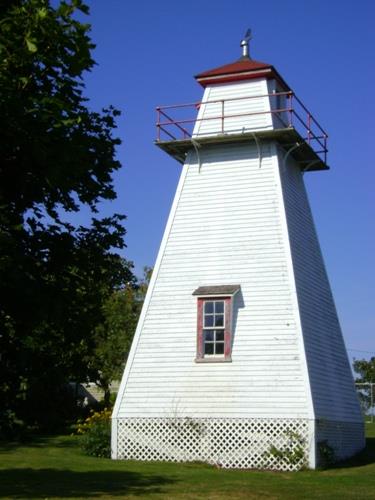
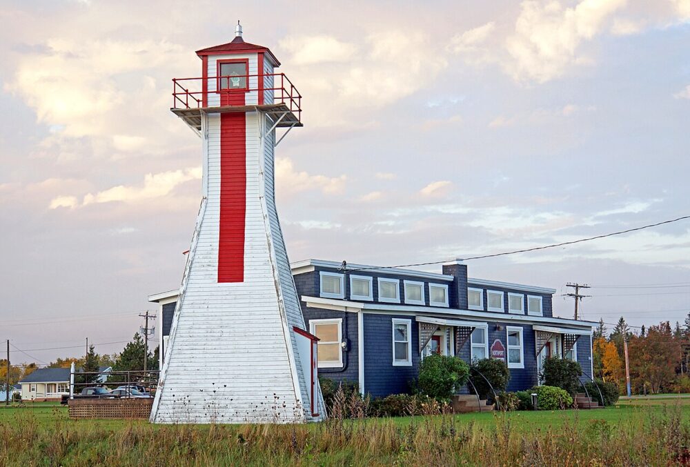
Photo: Province of PEI, C. Stewart, 2012
- Construction
- 1894
- Reconnaissance
- 2012
- Par
- Province de l'Île-du-Prince-Édouard
Le texte du répertoire, mot pour mot
Description
Wright's Back Range Light is a square tapered tower reaching a height of 9.8 m or 32' situated on Birch Point, which overlooks Paul's Bluff and the Northumberland Strait just west of the Victoria Harbour, Prince Edward Island.
Valeur patrimoniale
Wright's Back Range Light is valued for its historic use as navigational aid, its continuing visual presence, and as a symbolic reminder of Victoria's historic role as a marine transportation centre. The two sets of Palmer's and Wright's Range lights were used in conjunction with Leard's Range Lights to chart a safe course for ships to follow into Victoria Harbour.
Wright's Back Range Light was originally an open frame tower which was later enclosed. It was constructed without a separate lantern. The light shone from an upper window that faced seaward. The tower was built in 1894 on property owned by Charles L. Wright, the keeper of the light. Wright was paid $20 for the land and his salary as caretaker was $100 per year. His son Charles Evan Wright succeeded him in 1935 and maintained the light until 1959 when electricity was installed.
Wright's Front Range Light was crucial to the navigation of ships carrying visitors and residents and commercial goods into Victoria, which in the early 1900's was, along with Summerside, one of the most important harbours on the southwestern side of Prince Edward Island.
SourceHeritage Places files, Department of Education, Early Learning & Culture, Charlottetown, PE File # 4310-20/W15
Éléments caractéristiques
The heritage value of Wright's Back Range Light is evident in the following heritage character-defining elements:
- the overall massing of the building
- the square tapered construction
- the wood shingle cladding, painted white with red trim
- the superimposed gallery supported by metal brackets
- the size and placement of the windows and door
- the windows are topped with shed dormers
- the pediment over the door
- the balcony surrounding the top of the tower
- the smoke jack or smoke head at the apex of the tower
Fin du texte du répertoire
Emplacement
46.20726° N, 63.50445° W
Itinéraire (s’ouvre dans un nouvel onglet)L’inscription au répertoire ne rend pas un lieu accessible au public. Beaucoup sont des résidences ou des commerces privés; admirez-les depuis la rue.

Chargement de la carte…
À proximité
Les 40 lieux de Victoria
Lieux semblables
Les lieux dont la description du répertoire se rapproche le plus de celle-ci.
 Leards Range Front LighthouseVictoria, Ile Du Prince Edouard
 Summerside Back Range LightSummerside, Ile Du Prince Edouard
 Warren Cove Front Range LightRocky Point, Ile Du Prince Edouard
- Annandale Rear Range LightAnnandale, Ile Du Prince Edouard
- Malpeque Back Range LightDarnley, Ile Du Prince Edouard
 AjoutNorthport Rear Range LighthouseNorthport, Ile Du Prince Edouard
Tiré du Répertoire canadien des lieux patrimoniaux, dans sa dernière mise à jour du 12 décembre 2025. Le texte du répertoire est reproduit mot pour mot.