Bien patrimonial municipal
Voysey Farmhouse Site
Spy Hill RM 152, Saskatchewan
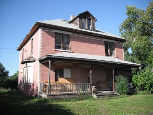
Photo: Clint Robertson, 2009.
- Construction
- 1917
- Reconnaissance
- 2007
- Par
- Administrations locales (Sask.)
Le texte du répertoire, mot pour mot
Description
The Voysey Farmhouse Site is a Municipal Heritage Property located in the Rural Municipality of Spy Hill No. 152, 0.8 kilometres east of the Village of Spy Hill. The property features a tree-sheltered farmstead containing a 1917 Foursquare-style wood-frame and red-brick veneer farmhouse distinguished by its use of buff-coloured brick detailing.
Valeur patrimoniale
The Voysey Farmhouse Site is of heritage value as the home of one of the community’s earliest settlers, John Voysey (1867-1945) and his family. Voysey homesteaded on an adjacent quarter-section of land in about 1895 and farmed until his death. John and his wife Margaret were active community members, with John serving on the school board, as a United Grain Growers member and running the local beef ring. Margaret was a member of the Ladies Aid and Women’s Missionary Society as well as an active church member and Sunday school teacher. The farm was owned by their son Alexander until his death in 2006. Alexander had resided in the house until the early 1980s.
The Voysey Farmhouse is also valued as a well-known architectural landmark in the community. Unlike the majority of houses built in the area at the time, the Foursquare-style Voysey farmhouse was constructed of brick and was substantial in size and character, containing five bedrooms. The red-brick house is exuberantly detailed with buff-coloured brick at corners, above the doors and windows, at the cornice, in banding and in the window sills. Also distinguishing the house is the full-width front veranda and bay window. Located just 0.8 kilometres from the village of Spy Hill, it is well-known to community members.
Source:
R.M. of Spy Hill No. 152 Bylaw No. 1-2007.
Éléments caractéristiques
The heritage value of the Voysey Farmhouse Site resides in the following character-defining elements:
-those elements of the farmhouse related to its architecture, such as its wood-frame construction with red-brick cladding and buff-coloured brick detailing, rectangular two-storey form with rectangular one-storey rear extension, the hip roof with flat top, wood shingle-clad, gable-roof dormers and closed tongue-and-groove eaves, the open, full-width front veranda with turned supports, a bay window, and one-over-one wooden sash windows;
-contextual elements of the site, such as the placement of the house on its original location and the tree-sheltered farmstead.
Fin du texte du répertoire
Emplacement
50.60738° N, 101.67183° W
Itinéraire (s’ouvre dans un nouvel onglet)L’inscription au répertoire ne rend pas un lieu accessible au public. Beaucoup sont des résidences ou des commerces privés; admirez-les depuis la rue.

Chargement de la carte…
À proximité
Lieux semblables
Les lieux dont la description du répertoire se rapproche le plus de celle-ci.
Tiré du Répertoire canadien des lieux patrimoniaux, dans sa dernière mise à jour du 12 décembre 2025. Le texte du répertoire est reproduit mot pour mot.