Bien inscrit au répertoire municipal
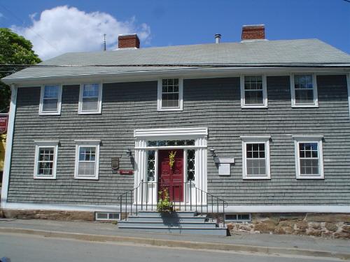
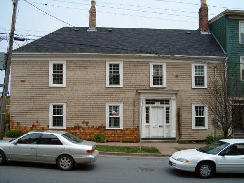
Solomon Bowlby House
Upper Clements, Nouvelle Ecosse
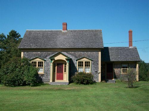
Photo: Heritage Division, NS Dept. of Tourism, Culture and Heritage, 2009
- Reconnaissance
- 1997
- Par
- Administrations locales (N.-É.)
Le texte du répertoire, mot pour mot
Description
Solomon Bowlby House, built c. 1855, is a one-and-a-half storey wooden home set back from the road at the north side of the highway which runs east-west through Upper Clements, Nova Scotia. The property and the building are included in the designation.
Valeur patrimoniale
The architectural value of the building as recognized by its municipal heritage designation is its vernacular tradition with New England Colonial influences and its many original features. The one-and-a-half storey wooden building has a medium-pitched end-gable roof with a small central chimney. Pilasters and return eaves outline the gable ends.
The three-bay symmetrical façade has fairly rare double windows, a distinctive central doorway, covered with a pedimented portico and is framed with sidelights. There is a summer kitchen addition on the north side.
Solomon Bowlby, a farmer, purchased the property consisting of thirteen acres of land in 1855; his name appears as a resident in this location on the A. F. Church map of 1876 and on the Western Counties Railway plan, dated 1876. The site has passed through several owners including: Ross Bowlby, Robert Curtis and James Essensa. The property has been owned by the Mailman family from 1920 until 2009 and is a valued testament to the agricultural past of Upper Clements.
SourceHeritage Property File no. OIBNS01765, Municipality of the County of Annapolis, 752 St. George Street, Annapolis Royal, N. S., B0S 1A0
Éléments caractéristiques
The character-defining elements of 2295 Highway 1 include:
-medium-pitched end-gable roof;
-pilasters and return eaves at gable ends;
-small central chimney;
-three-bay symmetrical façade with double windows;
-central doorway with pedimented portico framed with sidelights;
-wooden shingle siding.
Fin du texte du répertoire
Emplacement
44.68833° N, 65.59972° W
Itinéraire (s’ouvre dans un nouvel onglet)L’inscription au répertoire ne rend pas un lieu accessible au public. Beaucoup sont des résidences ou des commerces privés; admirez-les depuis la rue.

Chargement de la carte…
À proximité
 Goat Island Baptist Church200 m
 Lieu historique national du Canada de Port-Royal2,7 km · Port Royal · 1939
 Saint Edward's Anglican Church2,8 km · Clementsport
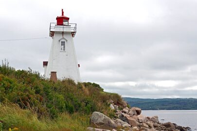 AjoutPhare de Schafner Point2,8 km · County of Annapolis · 1885
 Habitation de Port-Royal3,1 km · Port Royal · 1939
 Lieu historique national du Canada de l'Établissement-Melanson3,4 km · Lower Granville · 1664
Lieux semblables
Les lieux dont la description du répertoire se rapproche le plus de celle-ci.
Tiré du Répertoire canadien des lieux patrimoniaux, dans sa dernière mise à jour du 12 décembre 2025. Le texte du répertoire est reproduit mot pour mot.