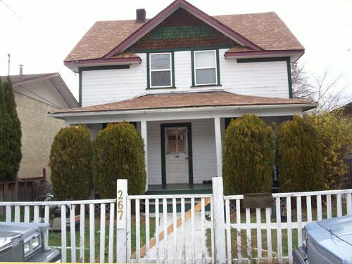
Photo: City of Penticton, 2007
- Construction
- 1916
- Reconnaissance
- 2008
- Par
- Administrations locales (C.-B.)
Le texte du répertoire, mot pour mot
Description
The Robb House is a two-storey, side-gabled vernacular house built in 1916 in Penticton, British Columbia.
Valeur patrimoniale
The Robb House has historic value for its association with the industrial centre which sprung up in this area of Penticton after the construction of the Kettle Valley Railroad. The house was built for C.H. Robb, who was from a lumber milling family that originally come to Okanagan Falls from Ontario, and then moved to Penticton in 1911.
Built in 1916, the Robb House is a good example of vernacular architecture from a period of rapid growth in Penticton. The form is reminiscent of the Ontario farmhouse. This style features a two-storey, side-gabled frame structure with a secondary cross-gable in the centre of the façade. The front door is centered and two double-hung windows are arranged symmetrically above. There is a full porch across the entrance façade. In 1916 the Penticton Herald reports that "Harry Robb, owner of the Okanagan Falls mill, and head of the Okanagan Falls Lumber Co., has gone to Penticton to take charge of a large planer for the Penticton Lumber Company." This coincides with the construction date of the Robb House in Penticton.
Architecturally, the house is also important because it retains its original exterior features, including the use of decorative saw-tooth shingles in the gables, the use of drop siding as the exterior cladding, and survival of the original double-hung windows and turned porch rails.
SourceCity of Penticton Civic File
Éléments caractéristiques
Key elements that define the heritage character of the Robb House include its:
-simple side-gabled form
-central cross-gable with returned eaves
-central entry with two double-hung windows above
-porch extending across the front façade
-original cladding including the drop siding, double hung windows, and decorative saw-tooth shingles in the gables
Fin du texte du répertoire
Emplacement
49.48527° N, 119.59530° W
Itinéraire (s’ouvre dans un nouvel onglet)L’inscription au répertoire ne rend pas un lieu accessible au public. Beaucoup sont des résidences ou des commerces privés; admirez-les depuis la rue.

Chargement de la carte…
À proximité
Les 54 lieux de Penticton
Lieux semblables
Les lieux dont la description du répertoire se rapproche le plus de celle-ci.
Tiré du Répertoire canadien des lieux patrimoniaux, dans sa dernière mise à jour du 12 décembre 2025. Le texte du répertoire est reproduit mot pour mot.