Bien patrimonial municipal
Old Masonic Lodge
Central Butte, Saskatchewan
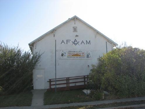
Photo: Government of Saskatchewan, Marvin Thomas, 2008.
- Construction
- 1930
- Reconnaissance
- 1991
- Par
- Administrations locales (Sask.)
Le texte du répertoire, mot pour mot
Description
The Old Masonic Lodge is a Municipal Heritage Property situated on a single lot on the east side of Main Street in the Town of Central Butte. The property features a wood-frame, one-storey building that was erected in 1930.
Valeur patrimoniale
The heritage value of the Old Masonic Lodge resides in its former role as the meeting place for the Central Butte Masonic Lodge No. 114 and Order of Eastern Star Chapter No. 44. After receiving its charter in 1915, the Central Butte Masonic Lodge met for several years in the upstairs rooms of a hardware store. The Eastern Star chapter, which was established in 1924, shared the same facilities. The Old Masonic Lodge was built in 1930, with lodge members volunteering most of the labour. The new hall was used by the Masons and the Eastern Star until 1989, when both organizations withdrew from Central Butte. Over the years, the building also provided space for a Family Activity Centre and a senior citizens group. It currently serves as the Town’s museum.
There is further heritage value in the property’s status as one of the Town’s oldest surviving buildings. The Central Butte town site was surveyed in 1914 following the arrival of the railroad. The new settlement was incorporated as a Village the following year. Today, the Old Masonic Lodge is one of only a few buildings that date to the Town’s earliest decades.
Source:
Town of Central Butte Bylaw # 3/91.
Éléments caractéristiques
The heritage value of the Old Masonic Lodge resides in the following character-defining elements:
-elements related to the building’s use as a Masonic lodge, including the Masonic emblem on the street-facing wall and the meeting space on the main floor;
-elements that speak to the building’s age and association with early town history, including its location on its original site, and its wood-frame construction, simple rectangular plan and gable roof.
Fin du texte du répertoire
Emplacement
50.79437° N, 106.50600° W
Itinéraire (s’ouvre dans un nouvel onglet)L’inscription au répertoire ne rend pas un lieu accessible au public. Beaucoup sont des résidences ou des commerces privés; admirez-les depuis la rue.

Chargement de la carte…
À proximité
Lieux semblables
Les lieux dont la description du répertoire se rapproche le plus de celle-ci.
Tiré du Répertoire canadien des lieux patrimoniaux, dans sa dernière mise à jour du 12 décembre 2025. Le texte du répertoire est reproduit mot pour mot.