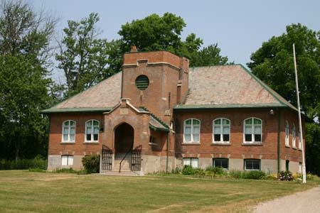
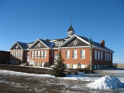
Photo: Ministry of Culture, 2007.
- Construction
- 1905
- Reconnaissance
- 1987
- Par
- Administrations locales (Ont.)
Le texte du répertoire, mot pour mot
Description
The Museum School is located at 656 Main Street North, on the east side of Main Street North, south of Highway 59, in the Village of Burgessville, Township of Norwich. The two-storey red-brick school was constructed in 1905.
The property was designated, by the Township of Norwich, in 1987, for its architectural or historic value or interest, under Part IV of the Ontario Heritage Act (By-law 32-87).
Valeur patrimoniale
The Museum School opened as S.S. #3 North Norwich in 1905 and served as the community elementary school until its closure in 1961. The Museum School, which was converted to a museum in 1976, is significant as it is representative of rural school heritage in Norwich Township. It now functions as a museum and interpretive centre that allows students of today to experience school life of the past. In addition to the school building, the Museum School also features a belfry to the southeast of the museum building, which commemorates its earlier use as a school.
The Museum School is constructed of red-brick in the Baronial style of architecture. Typical of this style, the School features a symmetrical plan, a projecting tiered buttress in front of a central square bell tower, and a steeply sloped roof. Also of note are the second-storey arched windows and the contrasting brickwork above the second-storey windows.
SourceTownship of Norwich, By-law 32-87.
Éléments caractéristiques
Character defining elements that contribute to the heritage value of the Museum School include its:
- stone above the main entry which notes the school's name, “S.S. #3 North Norwich”, and its date of construction, “1905”
- symmetrical plan
- red-brick construction
- steeply sloped roof
- projecting tiered buttress
- central square bell tower
- false-front sheltered entrance
- second-storey arched windows
- contrasting brickwork above the first-storey windows
- commemorative belfry to the southeast of the building
Fin du texte du répertoire
Emplacement
43.01956° N, 80.65218° W
Itinéraire (s’ouvre dans un nouvel onglet)L’inscription au répertoire ne rend pas un lieu accessible au public. Beaucoup sont des résidences ou des commerces privés; admirez-les depuis la rue.

Chargement de la carte…
À proximité
Les 13 lieux de Township of Norwich
Lieux semblables
Les lieux dont la description du répertoire se rapproche le plus de celle-ci.
Tiré du Répertoire canadien des lieux patrimoniaux, dans sa dernière mise à jour du 12 décembre 2025. Le texte du répertoire est reproduit mot pour mot.