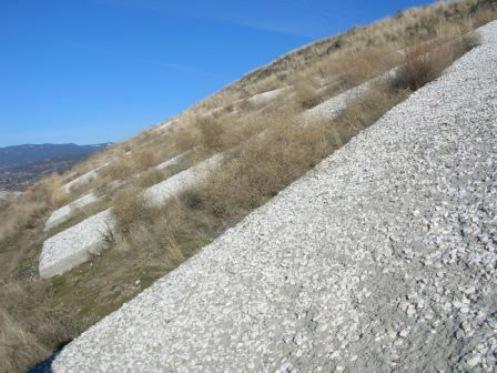
Photo: City of Penticton, 2006
- Construction
- 1937
- Reconnaissance
- 2006
- Par
- Administrations locales (C.-B.)
Le texte du répertoire, mot pour mot
Description
Munson Mountain is a prominent hill located on the North Bench which overlooks the city. It bears large silica and concrete letters spelling out the word "PENTICTON". It is highly visible from Highway 97 and from the Kettle Valley Railway right-of-way on the West Bench, where visitors have historically and currently approached the city from the north.
Valeur patrimoniale
Munson Mountain is valued because its pebble constructed sign is a symbol of civic pride which has been maintained by volunteer groups since its construction in 1937. Literally built by civic boosters to "put Penticton on the map", it was compared to the Hollywood sign. First constructed by members of the Board of Trade, it was improved in 1941 by Jaycees, Board of Trade members, and boy scouts. Between 1972 and 1983 volunteers hauled 44,000 pounds of silica rock to the site. In 1998 concrete was laid down and silica imbedded in it.
The mountain is also valued as a prominent geographic feature which stands out from the surrounding benchland and provides a panoramic view of the City. It has long had social significance as a site for local celebrations. The first recorded evidence of this use was on July 1, 1927 when a day of civic activities was capped off with a beacon fire on Munson Mountain.
SourceCity of Penticton Civic File for: 650 Lower Bench Road
Éléments caractéristiques
Key elements that define the heritage character of Munson Mountain include:
- the silica rock from a South Okanagan quarry, embedded in concrete, creating a sign measuring 54.33 feet (16.5m) high and 308.39 feet (93.99m) wide
- the mountain setting, including the undisturbed hill above the sign and natural vegetation around it
- the continuity of association with volunteer groups who have maintained the sign
- association with community celebrations
Fin du texte du répertoire
Emplacement
49.51550° N, 119.57362° W
Itinéraire (s’ouvre dans un nouvel onglet)L’inscription au répertoire ne rend pas un lieu accessible au public. Beaucoup sont des résidences ou des commerces privés; admirez-les depuis la rue.

Chargement de la carte…
À proximité
Les 54 lieux de Penticton
Lieux semblables
Les lieux dont la description du répertoire se rapproche le plus de celle-ci.
Tiré du Répertoire canadien des lieux patrimoniaux, dans sa dernière mise à jour du 12 décembre 2025. Le texte du répertoire est reproduit mot pour mot.