Bien patrimonial municipal
Municipal Office at Meota
Meota, Saskatchewan
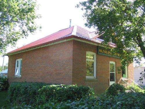
Photo: Government of Saskatchewan, J. Bisson, 2004
- Construction
- 1924
- Reconnaissance
- 1982
- Par
- Administrations locales (Sask.)
Le texte du répertoire, mot pour mot
Description
The Municipal Office at Meota is a Municipal Heritage Property located on two civic lots in the Village of Meota. The property features a red-brick building that was constructed in 1924.
Valeur patrimoniale
The heritage value of The Municipal Office at Meota resides in its association with the Village of Meota and surrounding municipality. Created out of a Local Improvement District, which had administered local services since 1907, the Rural Municipality of Meota No. 468 was formally organized on December 13, 1912. Its first two office buildings, both wood structures, burned down and were replaced by the current structure in 1924. Constructed to provide space for the general civic administration of the surrounding rural municipality, the building's symmetrical lines and brick construction reflect a simple, functional design while projecting an image of strength, permanence, and stability desired by public officials at that time. A noteworthy feature on the building is the copper geodetic benchmark implanted in the wall of the foundation. Used by federal geological surveys to mark vertical elevation, these three-inch, circular plates were used by subsequent surveyors to establish the elevation of nearby points.
One of the oldest buildings in the village, the Municipal Office at Meota remains an important part of the community's history.
Source:
Village of Meota Bylaw No. 4/82.
Éléments caractéristiques
The heritage value of The Municipal Office at Meota resides in the following character-defining elements:
-those elements that reflect the building's architectural design, such as its symmetrical lines, square form and massing, red-brick construction, window placement with sills, hip roof with gable dormer, brick detailing above windows and doorways, and concrete foundation and footings;
-the copper benchmark implanted in the foundation's wall;
-those features that speak to its use as a municipal office, including original signage, vault, and interior woodwork.
Fin du texte du répertoire
Emplacement
53.04100° N, 108.45192° W
Itinéraire (s’ouvre dans un nouvel onglet)L’inscription au répertoire ne rend pas un lieu accessible au public. Beaucoup sont des résidences ou des commerces privés; admirez-les depuis la rue.

Chargement de la carte…
À proximité
Lieux semblables
Les lieux dont la description du répertoire se rapproche le plus de celle-ci.
Tiré du Répertoire canadien des lieux patrimoniaux, dans sa dernière mise à jour du 12 décembre 2025. Le texte du répertoire est reproduit mot pour mot.