Bien patrimonial municipal
Moose Creek United Church and Cemetery
Moose Creek RM 33, Saskatchewan
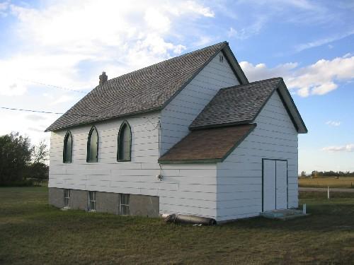
Photo: Government of Saskatchewan, Brett Quiring, 2004
- Construction
- 1916
- Reconnaissance
- 1991
- Par
- Administrations locales (Sask.)
Le texte du répertoire, mot pour mot
Description
Moose Creek United Church and Cemetery is a Municipal Heritage Property located within the Rural Municipality of Moose Creek No. 33 approximately ten kilometres southwest of Carlyle. The 0.75 hectare landscaped property features a cemetery and one-storey, wood-frame church built in 1916.
Valeur patrimoniale
The heritage value of the Moose Creek United Church and Cemetery lies in its status as the link between the community’s present residents and the original settlers. The church has been the centre of spiritual and social life since the church was built in 1916. Constructed by the pioneers of the district, the church remains as one of their most tangible legacies. The cemetery adjoining the church was established in 1918 and provides the final resting place of many of the area’s first settlers.
The heritage value of the property also lies in the landscape. The Moose Creek United Church and Cemetery is situated on large well-groomed grounds, reflecting property's importance to the community. The borders are defined by a partial shelter belt, and the cemetery is further separated from the church grounds by a loosely-treed border and an ornate brick and iron gate.
Source:
Rural Municipality of Moose Creek No. 33 Bylaw 50-91.
Éléments caractéristiques
The heritage value of the Moose Creek United Church and Cemetery resides in the following character-defining elements:
-those elements that reflect the property’s association with the district’s original pioneers, such as the location of the church and the cemetery on their original site;
-those elements of the landscape that reflect the important nature of the property, such as the well groomed lawns and the shelter belt and other treed sections;
-the brick and wrought iron gate.
Fin du texte du répertoire
Emplacement
49.52267° N, 102.29803° W
Itinéraire (s’ouvre dans un nouvel onglet)L’inscription au répertoire ne rend pas un lieu accessible au public. Beaucoup sont des résidences ou des commerces privés; admirez-les depuis la rue.

Chargement de la carte…
À proximité
Lieux semblables
Les lieux dont la description du répertoire se rapproche le plus de celle-ci.
Tiré du Répertoire canadien des lieux patrimoniaux, dans sa dernière mise à jour du 12 décembre 2025. Le texte du répertoire est reproduit mot pour mot.