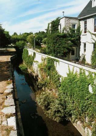
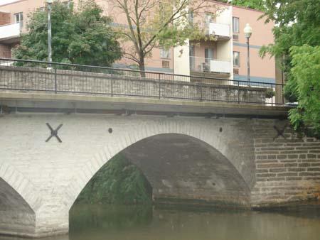
Photo: Gord Strathdee, 2007.
- Construction
- 1864
- Reconnaissance
- 1978
- Par
- Administrations locales (Ont.)
Le texte du répertoire, mot pour mot
Description
The Mill Race is located northeast of Queen Street East, along the eastern edge of the Thames River, in the Town of St. Marys. The limestone canal was constructed in 1864 and runs south from Trout Creek, under the Victoria Bridge, to the Thames River.
The property was designated by the Town of St. Marys, in 1978, for its historical or architectural value or interest, under Part IV of the Ontario Heritage Act (By-law 31-1978).
Valeur patrimoniale
The Mill Race is associated with the Ingersoll family and the development of the Town of St. Marys. The Ingersoll's erected the first saw and grist mills in the area in 1841. These first mills led to the settlement of the Town of St. Marys, the establishment of more mills and eventually to the construction of the Mill Race. The early development of the Town centred on these prosperous milling activities which produced a variety of goods for export and which would prove to be the Town's economic focus for over 130 years. Although the old mill buildings are gone, the Mill Race survives as a reminder of the importance of that industry to the development of St. Marys and the area and of the foresight of the Ingersoll's.
The Mill Race was constructed in 1864 of large, locally-quarried course limestone blocks, to form a channel alongside the Thames River, to provide power to local mills. Since its construction, the Mill Race has seen many changes, the first of which was only shortly after its construction. In order to allow the Mill Race to pass under Queen Street to the mills to the south, its course was altered and an additional small arch was built on the eastern end of the Victoria Bridge, in 1865.
The Mill Race is contextually linked to the Thames River, the Victoria Bridge and to the former mill sites. Together with the river, the bridge and the former mills, the Mill Race contributes to the broader cultural heritage landscape of St. Marys. The race is also important in defining the western edge of downtown St. Marys, running alongside prominent downtown buildings and under the Victoria Bridge.
SourceTown of St. Marys By-Law 31-1978.
Éléments caractéristiques
Character defining elements that contribute to the heritage value of the Mill Race include its:
- narrow and open flowing channels
- construction of large, course local limestone blocks
- route under the eastern arch of the Victoria Bridge to divert the race to the south side of Queen Street
- proximity and relationship to the Thames River, Victoria Bridge, and the former mill sites
- location directly west of downtown, defining the western boundary of downtown St. Marys
Fin du texte du répertoire
Emplacement
43.25900° N, 81.14500° W
Itinéraire (s’ouvre dans un nouvel onglet)L’inscription au répertoire ne rend pas un lieu accessible au public. Beaucoup sont des résidences ou des commerces privés; admirez-les depuis la rue.

Chargement de la carte…
À proximité
Les 12 lieux de Town of St. Marys

Lieux semblables
Les lieux dont la description du répertoire se rapproche le plus de celle-ci.
Tiré du Répertoire canadien des lieux patrimoniaux, dans sa dernière mise à jour du 12 décembre 2025. Le texte du répertoire est reproduit mot pour mot.