Territorial Historic Site
Mabel McIntyre House
Mayo, Yukon
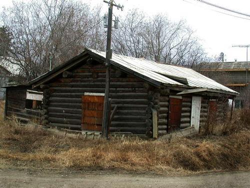
Photo: Yukon Government
- Construction
- 1921
- Reconnaissance
- 2003
- Par
- Gouvernement du Yukon
Le texte du répertoire, mot pour mot
Description
The Mabel McIntyre House is a territorially designated historic site that is a one-storey 16'X25' log cabin with shed attachment and the partial lots that it sits on, in the centre of the Village of Mayo's historic downtown.
Valeur patrimoniale
The Mabel McIntyre House was the first Mining Recorder's Office constructed in Mayo. Built in 1921, as the production of gold in the Klondike was declining, it heralded the onset of a mining boom that would make the Mayo Mining District the chief economic engine in the Yukon. The Mining Recorder's Office represented the federal government's broad and prominent administrative role in the community. The Mining Recorder's duties ranged from the agent enforcing mining regulations to Marriage Commissioner, Justice of the Peace and Juvenile Court Magistrate.
The building's rustic frontier style was characteristic of early, regional Mining Recorder's Offices in the Yukon. It was an integral part of the rapid development of the commercial district of the community and is the oldest building still located on its original site on Centre Street.
The building was later the residence of Mabel McIntyre, a member of the First Nation of Nacho Nyak Dun, who lived here from 1946 until 1981. Mabel was a noteworthy and respected community member, serving as postmistress for 30 years.
SourceMable McIntyre House, File No. 2630 30 02 02. Heritage Resources Unit, Cultural Services Branch, Yukon Government
Éléments caractéristiques
- The siting on the lot and its orientation towards Centre Street
- The cabin's simple rectangular plan, its modest size and rustic saddle-notched log construction
- architectural elements such as the roof, shed attachment, door and window openings, historic sashes and trim
- The lack of modern amenities and rough interior finishing
Fin du texte du répertoire
Emplacement
63.59324° N, 135.89643° W
Itinéraire (s’ouvre dans un nouvel onglet)L’inscription au répertoire ne rend pas un lieu accessible au public. Beaucoup sont des résidences ou des commerces privés; admirez-les depuis la rue.

Chargement de la carte…
À proximité
Lieux semblables
Les lieux dont la description du répertoire se rapproche le plus de celle-ci.
Tiré du Répertoire canadien des lieux patrimoniaux, dans sa dernière mise à jour du 12 décembre 2025. Le texte du répertoire est reproduit mot pour mot.