Bien patrimonial municipal
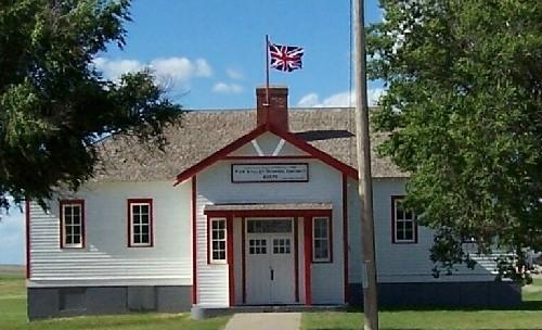
Kutawa School District No. 477
Mount Hope RM 279, Saskatchewan
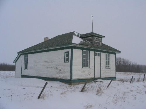
Photo: Government of Saskatchewan, 2007.
- Construction
- 1921
- Reconnaissance
- 2005
- Par
- Administrations locales (Sask.)
Le texte du répertoire, mot pour mot
Description
Kutawa School District No. 477 is a Municipal Heritage Property located within the Rural Municipality of Mount Hope No. 279 approximately six kilometres northeast of the Village of Punnichy. The property features a one-storey, wood-frame school constructed in 1921.
Valeur patrimoniale
The heritage value of the Kutawa School District No. 477 lies in its association with the education of the early residents of the district. In 1898, ratepayers of the area established the Kutawa School District No. 477 and a small log school was constructed on the property in 1899. The log school was used for more than twenty years until 1921, when the district outgrew the building and constructed the designated property. Using a Waterman & Waterbury Company design, commonly used for schools across the province, the building continued to be used to educate local children until 1967 when it was closed. At the time of its closure, the Kutawa School was one of the last rural, one-room schools operating in the province. The school is still used to host many community events and remains an important landmark in the community.
Source:
Rural Municipality of Mount Hope No. 279 Bylaw No. 2/05.
Éléments caractéristiques
The heritage value of the Kutawa School District No. 477 resides in the following character-defining elements:
-those elements that reflect the property’s association with education of the district’s early residents, including its location on its original position, open floor plan, blackboard, flag pole and sign above the main entrance;
-those elements that reflect typical schoolhouse design, including the wood-frame construction, wood siding, east elevation window wall, hip roof and, dormer window above the main entrance.
Fin du texte du répertoire
Emplacement
51.41867° N, 104.20815° W
Itinéraire (s’ouvre dans un nouvel onglet)L’inscription au répertoire ne rend pas un lieu accessible au public. Beaucoup sont des résidences ou des commerces privés; admirez-les depuis la rue.

Chargement de la carte…
À proximité
 Dr. Ernest Luthi Residence7,8 km · Punnichy · 1938
 Touchwood Hills Post Provincial Park10 km · Kellross RM 247 · 1879
 Raymore Pioneer Museum15 km · Raymore · 1910
 Stone Church Cemetery15 km · Emerald RM 277 · 1884
 Lieu historique national du Canada de l’Ancien-Pensionnat-Indien-de-Muscowequan15 km · Muskowekwan First Nation · 1930
 St. John Bohoslav Krasne Church21 km · Big Quill RM 308 · 1927
Lieux semblables
Les lieux dont la description du répertoire se rapproche le plus de celle-ci.
Tiré du Répertoire canadien des lieux patrimoniaux, dans sa dernière mise à jour du 12 décembre 2025. Le texte du répertoire est reproduit mot pour mot.