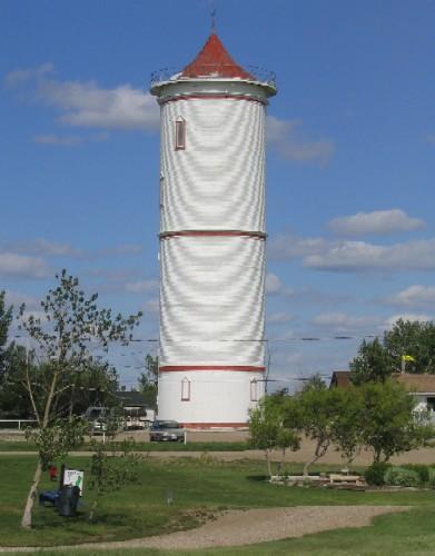
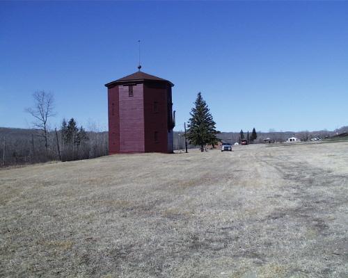
Photo: Government of Saskatchewan, Brett Quiring, 2005.
- Construction
- 1915
- Reconnaissance
- 1982
- Par
- Administrations locales (Sask.)
Le texte du répertoire, mot pour mot
Description
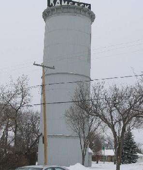
The Former Water Tower is a Municipal Heritage Property featuring of a 30 metre wood-and-steel structure constructed in 1915. The tower is located on two town lots at the corner of Queen Elizabeth Boulevard and East Avenue in the Town of Kamsack.
Valeur patrimoniale
The heritage value of the Former Water Tower lies in its association with Kamsack’s water system. The tower was built in 1915 and provided Kamsack's domestic water supply until it was replaced in 1977.
The heritage value of the property also resides in its coastal lighthouse-inspired architecture. The Former Water Tower is one of a group of ten water towers constructed in Saskatchewan between 1910 and 1915 which were influenced by the design of coastal lighthouses. This is reflected in the cylindrical design, wood façade which encases the steel water tank, and spiral staircase leading up to the roof. The façade features windows spiralling up the structure parallel to the staircase. Of the original ten lighthouse-inspired water towers, the Kamsack Water Tower is among the four that remain.
The heritage value of the property also resides in its status as a landmark in the community. In 1944, the tower’s original peaked roof was destroyed in a storm. During the repair of the tower, a flat roof was built and a large electric “Kamsack” sign was installed on top. The sign is visible from most areas in the town and surrounding countryside, serving the community as the defining feature of its landscape.
Source:
Town of Kamsack Bylaw No. 10/82.
Éléments caractéristiques
The heritage value of the Former Water Tower resides in the following character defining elements:
-those architectural elements that speak to its coastal lighthouse design, such as its window arrangement, cylindrical shape and cornice;
-those architectural elements that speak to its use as a water tower, including the steel tank and wooden housing;
-those elements that contribute to the property’s status as a local landmark, such as the electric “Kamsack” sign and the tower's position on its original location.
Fin du texte du répertoire
Emplacement
51.56493° N, 101.88968° W
Itinéraire (s’ouvre dans un nouvel onglet)L’inscription au répertoire ne rend pas un lieu accessible au public. Beaucoup sont des résidences ou des commerces privés; admirez-les depuis la rue.

Chargement de la carte…
À proximité
Les 4 lieux de Kamsack Royal Canadian Legion - Kamsack Branch No. 24650 m · 1908
 Capital Theatre at 566 First Street1,1 km · 1948
 Former Power Building2,2 km
 Lieu historique national du Canada des Doukhobors à Veregin14 km · Veregin · 1904
 Veregin Doukhobor Prayer Home14 km · Veregin · 1917
 Greek Catholic Church of Transfiguration23 km · Sliding Hills RM 273 · 1931
Lieux semblables
Les lieux dont la description du répertoire se rapproche le plus de celle-ci.
Tiré du Répertoire canadien des lieux patrimoniaux, dans sa dernière mise à jour du 12 décembre 2025. Le texte du répertoire est reproduit mot pour mot.