Terre, structure ou édifice patrimonial municipal
Burnt Head Arch Municipal Heritage Site
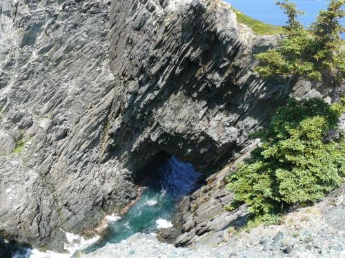
Photo: Deborah O'Rielly/ HFNL 2008
- Reconnaissance
- 2007
- Par
- Municipalités de TNL
Le texte du répertoire, mot pour mot
Description
The Burnt Head Arch Municipal Heritage Site is the site of a naturally formed rock archway located in the abandoned community of Deep Gulch, near Cupids. The municipal designation encompasses the archway and the area immediately around it.
Valeur patrimoniale
The Burnt Head Arch has been designated because it has environmental value.
The Burnt Head Arch is environmentally valuable as a natural phenomenon. Made of shale and granite the arch is a gap in the coastline geology located on the south side of Cupids. The cliff side is approximately 30.5m high from the ocean, and the arch opening is approximately 9m from the surface of the water. The arch is accessible by boat, and one can go through it to find a small, shallow pool which is enclosed on three sides by vertical rock. The Burnt Head Arch is a popular destination for hikers who walk the Burnt Head Trail. The trail takes hikers through three abandoned communities: Deep Gulch, Noder (North) Cove and Greenland. Remnants of these villages are still visible, and one can hike through them along the North Atlantic coastline. The hiking trail leads to the arch and the vista from the site is panoramic.
SourceTown of Cupids, Meeting held April 3, 2007
Éléments caractéristiques
All those natural elements of the arch, which help define its shape and formation as a sea arch, including:
-composition of naturally formed shale and granite in an arch-shape;
-proximity to abandoned communities; and -proximity to hiking trail leading to and from Cupids.
Fin du texte du répertoire
Emplacement
47.56919° N, 53.20068° W
Itinéraire (s’ouvre dans un nouvel onglet)L’inscription au répertoire ne rend pas un lieu accessible au public. Beaucoup sont des résidences ou des commerces privés; admirez-les depuis la rue.

Chargement de la carte…
À proximité
Les 5 lieux de Cupids Butler Property1,2 km · Cupids · 1905
 Old Lighthouse Site Municipal Heritage Site2,5 km · Cupids
 Phare2,6 km · North Head · 1885
 Bulger, A Name Rock Municipal Heritage Site3 km · Cupids
 Landfall (Kent Cottage) Registered Heritage Structure3 km · Brigus
 John Guy Flag Site Municipal Heritage Structure3,2 km · Cupids · 1910
Lieux semblables
Les lieux dont la description du répertoire se rapproche le plus de celle-ci.
Tiré du Répertoire canadien des lieux patrimoniaux, dans sa dernière mise à jour du 12 décembre 2025. Le texte du répertoire est reproduit mot pour mot.